


403
Sorry!!
Error! We're sorry, but the page you were looking for doesn't exist.

Weather Dept Sounds Red Alert In Kashmir
(MENAFN- Kashmir Observer)
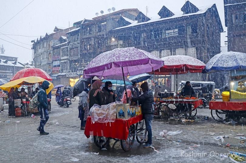
KO Photo By Abid Bhat
Heavy Snowfall Likely To Trigger Avalanches, Hit Surface & Air TrafficSrinagar- The weather department on Friday issued a red alert for heavy to very heavy snowfall in Jammu and Kashmir that could trigger avalanches and landslides at vulnerable places, besides disrupt surface and air traffic in the Union Territory.
“IMD issues Red Colour (be vigilant) weather warning for J&K for January 7,” an official of the MeT said.
Currently, it is snowing at most places of Kashmir and hilly areas of Jammu while raining at a few places of Jammu region.
“Expect further increase in rain/snow intensity as the day progresses with the main intensity of heavy to Very heavy rain/snow during 7th (night) and January 8th,” he said in a statement.“There would be gradual improvement from January 9th morning onwards in J&K.
There are four types of colour codes signifying the level of caution: green which means no action, yellow—situation to be watched), amber –government agencies need to be prepared for severe weather and red –action needed by the agencies.
The MeT official said the weather system may affect surface and air transportation, mainly on Saturday.“It may cause an avalanche/landslide in vulnerable spots.”
The MeT office has urged people not to venture in avalanche prone areas, follow traffic advisory seriously as well as maintain proper ventilation of their rooms.
31 Flights Operate, 6 Cancelled on Srinagar RouteAt least 31 flights operated to and fro Srinagar international airport before sudden change in weather while six others were cancelled on Friday, officials said.
“Due to sudden change in weather and snowfall in the evening we could operate only 31 flights today.
6 flights have been cancelled,” AAI said in a tweet.
Yesterday 35 flights operated while 6 others were cancelled. In the last four days 91 flights to and fro the Srinagar airport were cancelled. While 42 flights were cancelled on Tuesday, as many as 37 could not operate on Wednesday.
KU Postpones All Exams Scheduled TodayMeanwhile the University of Kashmir has postponed all examinations that were scheduled on Saturday due to inclement weather conditions, said an official on Friday.
'It is notified for the information of all the concerned that due to inclement weather conditions, all UG/PG/Professional exams of Kashmir University scheduled on 8-01-2022 stand postponed,' Prof Irshad Ahmad Nawchoo, Controller of Examinations said in a statement.
He further said that fresh dates for postponed papers will be issued separately
Gulmarg Freezes at Minus 5.5°CMeanwhile, the MeT official said that Srinagar recorded rainfall of 3.1mm in the last 24 hours till 0830 hours today.
Srinagar recorded a low of 2.6°C against previous night's 0.3°C. It was 4.5°C above normal for this time of the year in Srinagar, he said.
Gulmarg, recorded a low of minus 5.5°C against minus 3.4°C on the previous night at the world famous resort, he said.
Qazigund received 4.6mm of rain in the last 24 hours while the gateway town of Kashmir recorded a low of 0.4°C, same as witnessed on the previous night, he said.
Pahalgam, the famous resort in south Kashmir which had 0.4cms of fresh snowfall recorded a low of minus 0.4°C against minus 0.8°C on previous night, he said.
Kokernag, also in south Kashmir, recorded a low of minus 0.2°C against minus 0.7°C on previous night, the official said.
Kupwara town in north Kashmir, recorded a minimum of 0.8°C against 0.0°C as on the previous night, the official said.
Jammu, with 4.6mm of rain, recorded a low of 11.1°C, up eight notches from the previous night and normal of 7.3°C for the J&K's winter capital during this time of the year, he said.
Ladakh's Leh recorded a low of 1.5°C against last night's minus 7.6°C while Kargil automatic station recorded a minimum of minus 9.8°C while Drass recorded minus 12.4°C, the official said.
Kashmir is currently under the grip of the 40-day harshest winter period known as 'Chilla-i-Kalan' which began on December 21.
It is a period when a cold wave grips the region and the temperature drops considerably, leading to the freezing of water bodies and water supply lines.
Chances of snowfall are the highest during this period and most areas, especially in the higher reaches, receive heavy to very heavy snowfall.
The 'Chilleh Kalan' will end on January 31, but the cold wave will continue with a 30-day-long 'cold period.

Legal Disclaimer:
MENAFN provides the
information “as is” without warranty of any kind. We do not accept
any responsibility or liability for the accuracy, content, images,
videos, licenses, completeness, legality, or reliability of the information
contained in this article. If you have any complaints or copyright
issues related to this article, kindly contact the provider above.
Most popular stories
Market Research

More Story


Comments
No comment