


403
Sorry!!
Error! We're sorry, but the page you were looking for doesn't exist.

Wayanad Landslides: ISRO's Satellite Images Show Extent Of Damage; Crown Of 1550M, Debris Travelled 8Km Along
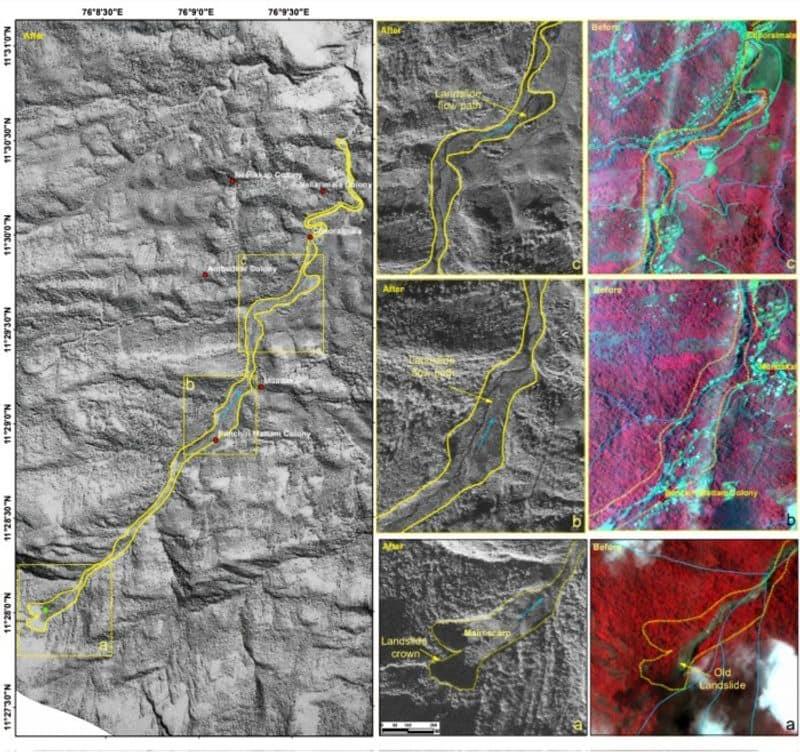
(MENAFN- AsiaNet News) Kerala's Wayanad district, which was recently struck by twin landslides, have caused unprecedented devastation, claiming more than 300 lives and injuring at least 200 individuals. The landslides have also destroyed approximately 86,000 square metres of land. The National Remote Sensing Centre (NRSC), a key institution under the Indian Space Research Organisation (ISRO), has used high-resolution satellite imagery to reveal the full extent of the damage.
Magnitude of the disaster
The landslides, which originated from an altitude of 1,550 metres near Chooralmala town, resulted in a massive debris flow that extended 8 kilometers along the Mundakkai river. The powerful flow of debris has obliterated towns and settlements in its path, leading to significant damage to houses and infrastructure.
ISRO's satellite systems, including Risat and Cartosat-3, have provided crucial before-and-after images of the affected areas. Risat's cloud-penetrating radar and Cartosat-3's advanced optical imaging have allowed for a comprehensive assessment of the disaster's impact. The imagery shows dramatic alterations in the landscape, including the widening of the Mundakkai river and breaches in its banks.
Detailed assessment by NRSC
According to the NRSC report,“A major debris flow was triggered by heavy rainfall in and around the Chooralmala town of Wayanad. Very high-resolution Risat synthetic aperture radar (SAR) images from July 31 show the entire extent of the debris flow from the crown to the end of the run-out zone. The approximate length of the flow is around 8 kilometers. The crown zone is a reactivation of an older landslide.”
The report further details,“The size of the main scarp of the landslide is 86,000 square meters. The debris flow has widened the course of the Mundakkai river, causing breaches in its banks. Houses and other infrastructure located along the banks have been severely damaged by the debris flow.”
Innovations in landslide detection
In response to the increasing frequency and intensity of such disasters, NRSC scientists have developed a new method for rapid landslide detection using satellite imagery and advanced deep learning techniques. Traditional methods of landslide mapping, which were either manual or semi-automatic, were time-consuming and less efficient. The new approach utilizes a deep learning model known as DeepLabV3+, which facilitates rapid regional mapping crucial for disaster mitigation and emergency response.
This model, initially developed for mapping landslides in the Himalayas and Western Ghats of India, including Wayanad and Kodagu districts, has been tested in several states including Maharashtra, Kerala, Karnataka, Mizoram, and Uttarakhand. The results have been compared to past landslide inventory data, proving the effectiveness of this method in providing timely information for disaster management and planning, especially in difficult-to-access terrains.
Historical context and future preparedness
In February 2023, ISRO released the Landslide Atlas of India, documenting around 80,000 landslides across 17 states and two Union Territories in the Himalayas and Western Ghats from 1998-2022. The atlas ranked 147 districts based on landslide exposure and socio-economic factors, identifying Wayanad as one of the most vulnerable districts.
The recent disaster in Wayanad underscores the critical need for continued monitoring and preparedness in landslide-prone areas. The new technological advancements in satellite-based detection and deep learning offer hope for more effective disaster management and timely interventions in the future.

Legal Disclaimer:
MENAFN provides the
information “as is” without warranty of any kind. We do not accept
any responsibility or liability for the accuracy, content, images,
videos, licenses, completeness, legality, or reliability of the information
contained in this article. If you have any complaints or copyright
issues related to this article, kindly contact the provider above.
Most popular stories
Market Research


Comments
No comment