(MENAFN- Newsfile Corp)
Vancouver, British Columbia--(Newsfile Corp. - September 10, 2024) - New Destiny mining Corp. (TSXV: NED) , (the " Company " or " NED ") provides a further update on its 2024 drilling program at the Treasure Mountain project, near Princeton, BC.

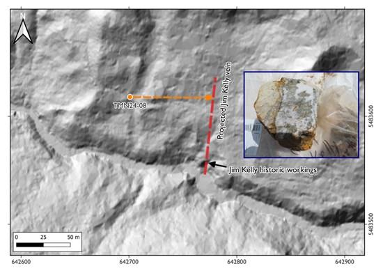
Figure 1. Map showing the location of hole TMN-08 (blue circle) at the Jim Kelly area. The red dashed line shows the projection of the Jim Kelly vein, and the blue dashed arrow shows the orientation of the drill hole. The inset photo shows the Jim Kelly vein sampled from the historic workings that consists of coarse pyrite within a quartz vein (vein width 8-10 cm).
To view an enhanced version of this graphic, please visit:
The drill rig has moved to the Jim Kelly target area. This target was chosen as previous work had identified a set of veins that have historically been mined. Jim Kelly is a gold vein target where a 2018 grab sample yielded 11.3 g/t gold. Hole TMN24-08 aimed to test the extension of this vein along strike to the north (see map above).

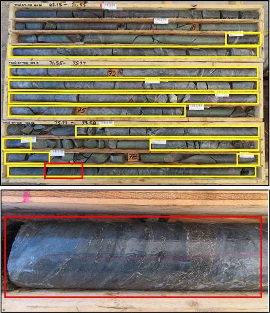
Figure 2. Photo of core from hole TMN24-08 showing part of the interval of the silicified zone with pyrite (yellow box) and the photo shows a close-up (red box). The interval of this silicified zone goes from 70.24 to 83.2 m (12.96 meters in core length).
To view an enhanced version of this graphic, please visit:
Hole TMN24-08 intersected a 12.96 meter interval of a highly silicified zone with disseminated pyrite (see yellow boxes on photo below from 70.24 to 83.2 meters including some intervals of cross-cutting andesitic dikes. The zone is interpreted as an expression of the mineralization found at the Jim Kelly workings, extending 60 meters towards the north.
Additionally, hole 8 also intersected from 66.07 to 68.77 m a zone with disseminated pyrite, pyrrhotite, and chalcopyrite with net textured sulfides in a silicified mafic intrusion (see photo below).
The next hole will test the extension of the Jim Kelly vein at depth.

Figure 3. Photo of core (NQ) from hole TMN24-08 showing a close-up of the interval from 66.07 to 68.77 m, that shows pyrite, pyrrhotite, and chalcopyrite in a micro-net texture within a mafic intrusion.
To view an enhanced version of this graphic, please visit:
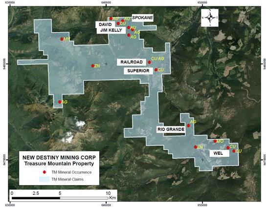
The Treasure Mountain property covers 10,819 hectares and is located 38 km west of the Copper Mountain mine at Princeton in southern BC. Targets on the property include critical minerals in porphyry copper-moly deposits, and gold-quartz vein and polymetallic silver-rich vein deposits.

Map showing Treasure Mountain property and targets for 2024
To view an enhanced version of this graphic, please visit:
Readers are cautioned that historical records referred to in this News Release have been examined but not verified by a Qualified Person. Further work is required to verify that historical records referred to in this News Release are accurate.
Dr. Mathew Ball, P.Geo., a Qualified Person as defined by NI 43-101 and consultant to the Company, approved the technical information contained in this News Release.
ON BEHALF OF THE BOARD OF DIRECTORS
MENAFN10092024004218003983ID1108657217
Legal Disclaimer:
MENAFN provides the information “as is” without warranty of any kind. We do not accept any responsibility or liability for the accuracy, content, images, videos, licenses, completeness, legality, or reliability of the information contained in this article. If you have any complaints or copyright issues related to this article, kindly contact the provider above.