


403
Sorry!!
Error! We're sorry, but the page you were looking for doesn't exist.

Mapbox Launches Enhanced Raster Data Support For Advanced Map Visualizations And Weather Services
(MENAFN- PR Newswire)
SAN FRANCISCO, Aug. 19, 2024 /PRNewswire/ -- Mapbox, a global leader in location technology, introduced new capabilities for its Mapbox Tiling Service (MTS) to efficiently process, style, and serve raster data from weather visualizations to custom satellite and aerial imagery. The numerical information in NetCDF and GRIB raster data now persists from processing to render, and can be styled for dynamic colorization creating visually stunning, interactive, and engaging weather maps. Commercial and national government agencies, and other media and trade organizations that work with weather data can now use these new methods of animating raster particles to predict how weather will behave, providing end users with specific and accurate insight to aid with decision-making.
Continue Reading
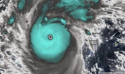
Hurricane Beryl visualized near peak intensity.
Hurricane Beryl visualized near peak intensity.
Raster Particle Animation
The new MTS capabilities support adding data-driven particle animation s to digital maps, a visualization technique that is ideal for data that includes multiple attributes such as magnitude and direction of wind, waves, or ocean currents. Particle animation helps to visualize how the weather will behave when data comes in lengthy increments, providing users with a more intuitive understanding of weather patterns. It also enables particles to persist when zooming and panning, giving users a more seamless experience within web and mobile applications.
Streamlined Support for Raster Data
MTS offers end-to-end processing, tiling, and hosting services for spatial data making it an all-in-one solution. Companies that use Mapbox as a single tech stack and pipeline for raster and vector data can now use internal resources to focus on engineering features that differentiate their product rather than building hard-to-maintain, expensive and undifferentiated proprietary processing systems.
"Self-hosted data processing pipelines can be cumbersome and full of failure points, often requiring significant time and resources to develop, host, monitor and maintain. With raster support for MTS, you get all the control you need without the overhead of building and managing your own tooling," said Anthony Goddard, Expedition Map Maker at ZeroSixZero. "This has allowed us to save hosting costs and free up time to spend on developing features for users rather than troubleshooting pipelines."
"Mapbox partners with the most well-known weather providers to offer easy access to accurate and timely weather information, helping our customers keep the public safe and informed while reducing costs and time in development," said Alistair Miller, product manager of Imagery, Mapbox. "The expanded MTS support for raster data equips our customers to deliver the most performant visualizations possible to end users."
Fine-tuned Tileset Customization
MTS also includes
the ability to create tailored tileset 'recipes' that improve ease of development for customers. The recipes configure a set of rules that tell MTS how to process data into tiles, providing fine control over tile generation decisions such as simplification, zoom level extent, and attribute, time-step, or band manipulation. With this level of flexibility, companies have a greater degree of control over their raster data than what other tiling solutions provide.
"Mapbox provides a solution where we will not have to depend on maintaining our own Geoserver since the processing and hosting is done with Mapbox," said Dr. Jay Shafer, director of Utilities, Disaster Tech, Inc. "Instead of having to cache our own raster tiles Mapbox does this for us which allows us to scale to many customers."
Read more about Mapbox Tiling Service (MTS) and how Mapbox enables you to process, style, and render raster data on this page .
To learn more about Mapbox solutions for the weather industry, in addition to processing raster data, see this page:
.
For technical details, view the Raster MTS documentation:
To start processing raster data, you first need a Mapbox account. You can sign up here:
About Mapbox
Mapbox is the leading maps and location platform powering a new generation of location-aware applications. Mapbox is the only platform that equips organizations with the full set of tools to power the navigation for people, packages, and vehicles everywhere. More than 4 million registered developers and 40 percent of Fortune 500 companies have chosen Mapbox because of the platform's flexibility, security, and privacy compliance. Organizations use Mapbox applications, data, SDKs and APIs to create customized and immersive experiences that delight their customers.
For more information, visit .
SOURCE Mapbox

Legal Disclaimer:
MENAFN provides the
information “as is” without warranty of any kind. We do not accept
any responsibility or liability for the accuracy, content, images,
videos, licenses, completeness, legality, or reliability of the information
contained in this article. If you have any complaints or copyright
issues related to this article, kindly contact the provider above.
Most popular stories
Market Research

More Story


Comments
No comment