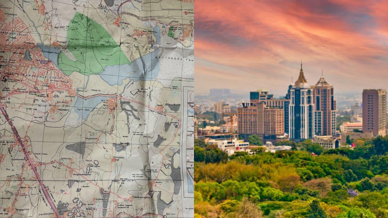
Bengaluru's 1983 Map Goes Viral: Jayanagar Was The Hub, HSR Layout Didn't Exist
Bengaluru: The city of Bengaluru, known today as India's Silicon Valley, has undergone rapid expansion over the past four decades. But a viral photo of a 42-year-old map from 1983 is now sparking nostalgia and debate online. Shared by user Dravisha on X (formerly Twitter), the map shows a very different Bengaluru, one without HSR Layout and with Jayanagar as the central hub of the city. The post has ignited discussions on how Bengaluru's neighborhoods have evolved, how land once covered with lakes has been converted into residential layouts, and how this impacts modern flooding problems.
Bengaluru in 1983: No HSR Layout, Indiranagar Barely There
Dravisha, who shared the map, wrote:
“We bought Bengaluru's map (1983 edition) from a collector. (42 years old). And it turns out, HSR & Indiranagar are non-existent. Jayanagar is almost central of the city. Now, onto finding our fav places on the map and see if they existed back then xD.”
While HSR Layout was nowhere to be found, Jayanagar stood as the city's prominent hub. Indiranagar, which many thought was missing, does appear, but only as a small neighborhood in fine print, much smaller than it is today.
We bought Bengaluru's map (1983 edition) from a collector. (42 years old)And it turns out, HSR & Indiranagar are non existent. Jayanagar is almost central of the city. Now, onto finding our fav places on the map and see if they existed back then xD twitter/NBWlApcELJ
- Dravisha (@dravishakatoch) August 30, 2025
Prominent Landmarks in the 1983 Map
According to the viral map, the following areas and routes stood out in 1983 Bengaluru:
- City Centre and Heart of Bengaluru: MG Road, Shivajinagar, Cantonment, and Ulsoor Lake. Northern Outskirts: Hebbal, Yelahanka Road, and Bellary Road were still semi-rural stretches. Eastern & Western Routes: Whitefield and Tumkur Road appeared more like small towns and approach roads. Southern Bengaluru: Jayanagar, Banashankari, and JP Nagar were dense, planned layouts, forming the city's biggest residential clusters.
Debate Over Indiranagar's Existence
Some netizens argued that Indiranagar was very much a part of Bengaluru in 1983, pointing out that former cricketer Rahul Dravid grew up there. Responding to this, others clarified that while Indiranagar existed, it was a much smaller neighborhood and did not resemble today's bustling residential and commercial hub.
Bengaluru's Vanishing Lakes
Interestingly, netizens also focused on how the map highlighted lakes and streams that have now disappeared. Many pointed out that neighborhoods such as HSR Layout, Koramangala, and areas around Manyata Tech Park were built over lakebeds, leading to today's flooding issues during heavy rains.
One user remarked,“This is the map to refer while buying a house. If there was a lake there, don't buy it.” Another shared the pain of explaining to officials that HSR Layout land records were still in the name of Haralukunte village, showing how Bengaluru's expansion erased older names.
Not Just South Bengaluru
Addressing assumptions that the map only covered South Bengaluru, Dravisha clarified:
- Northern stretches like Hebbal, Yelahanka, and Airport Road were included but semi-rural. The map clearly displayed MG Road, Ulsoor, Shivajinagar, and Cantonment as the heart of the city. Insets on the map showed approach roads to Tumkur, Hosur, and Kolar, confirming that it covered the entire city.
Netizens React with Humor and Nostalgia
The viral post sparked amusing reactions as well. One person noted how older residents still consider Koramangala as a remote area, joking,“Even today, if I tell my 84-year-old neighbour that I'm visiting someone in Koramangala, he looks at me like - who on earth goes there?”
Even today, if I tell my 84 yo neighbour that I'm visiting someone in Koramangala, he looks at me with an expression that says“who on earth goes to Koramangala??”
- Pratul (@prxtl) August 31, 2025
The viral 1983 map has not just rekindled nostalgia but also highlighted Bengaluru's urban planning challenges, reminding residents how the city's rapid growth came at the cost of its lakes and green cover.
Legal Disclaimer:
MENAFN provides the
information “as is” without warranty of any kind. We do not accept
any responsibility or liability for the accuracy, content, images,
videos, licenses, completeness, legality, or reliability of the information
contained in this article. If you have any complaints or copyright
issues related to this article, kindly contact the provider above.
Most popular stories
Market Research

- What Is The Growth Rate Of The Europe Baby Food And Infant Formula Market In 2025?
- UK Digital Health Market To Reach USD 37.6 Billion By 2033
- Spycloud Launches Consumer Idlink Product To Empower Financial Institutions To Combat Fraud With Holistic Identity Intelligence
- Cryptogames Introduces Platform Enhancements Including Affiliate Program Changes
- What Does The Europe Cryptocurrency Market Report Reveal For 2025?
- Excellion Finance Launches MAX Yield: A Multi-Chain, Actively Managed Defi Strategy


Comments
No comment