


403
Sorry!!
Error! We're sorry, but the page you were looking for doesn't exist.
Questcorp Mining And Riverside Resources Complete Expanded Drone Aeromagnetic Survey At La Union Project
(MENAFN- Newsfile Corp)
Questcorp Mining and Riverside Resources Complete Expanded Drone Aeromagnetic Survey at La Union Project
May 21, 2026 3:05 AM EDT | Source: Questcorp Mining Inc.
Vancouver, British Columbia--(Newsfile Corp. - May 21, 2026) - Questcorp Mining Inc. (CSE: QQQ) (OTCQB: QQCMF) (FSE: D910) (the "Company" or "Questcorp") along with partner Riverside Resources, has completed an expanded aeromagnetic drone survey at the La Union Project in Sonora, Mexico. The new data, together with property-wide structural mapping and the high-grade Phase 2 sampling results announced May 5, 2026, are being used to refine drill targets ahead of the fully permitted summer drill program. Drill roads and pads are currently being established and preparations drill mobilization are progressing rapidly.
Highlights
- Expanded drone aeromagnetic survey adds a further 248 line km of total drone coverage, consisting of 193 line km (145 flight lines) along with 55 line km of tie lines (20 tie lines), building on the 2025 baseline dataset. Improved imaging of structures beneath post-mineral cover, including newly identified northwest-trending structures interpreted from spring 2026 field mapping as potential ore controls. Improved imaging of structures beneath post-mineral cover, including newly identified northwest-trending structures interpreted from spring 2026 field mapping as potential ore controls. Integrated structural mapping with detailed 1:1,000 geologic field mapping of target areas and district-scale 1:5,000 geologic mapping to characterize interpretations at depth that may be associated with mineralization. An Induced Polarization (IP) geophysical survey is expected to commence shortly to further derisk the Phase 2 drill targeting.
Construction of drill roads and pads has commenced for the upcoming Phase 2 drill program. Questcorp President & CEO Saf Dhillon commented: "The key objective of the early stages of the Phase II Exploration Program is to derisk the up-coming fully funded drill program to the maximum extent possible. John-Mark and his Riverside technical and field teams continue to maximize the effectiveness of every exploration dollar, strengthening the datasets and locating consistent high-grade mineralization across multiple zones, while concurrently identifying new targets that significantly expand the project's footprint."
"The expanded aeromagnetic survey provides a much clearer view of the Union Project structural framework at depth, and combined with the high-grade sampling results released earlier this month we have the data in hand to refine our Phase 2 drill targets," said John-Mark Staude, President and CEO, Riverside Resources Inc. "The program is going well and our teams are working to prepare for the launch of drilling that is coming soon while expanding the drill targets where high grade gold and base metals were historically mined, with geophysics now helping to image potential source targets at depths."
Survey Overview
The survey was flown with a magnetometer suspended beneath a drone along parallel flight lines, with tie lines flown perpendicular to level the dataset. The expanded grid extends magnetic coverage across the property in all directions beyond the 2025 baseline survey, providing district-wide imaging of structural features and magnetic bodies at depth. The 2025 dataset was a key input into planning the Phase 1 drill holes; the expanded 2026 dataset will allow these structures to be traced more confidently beneath post-mineral cover and build a more complete exploration model for Union.
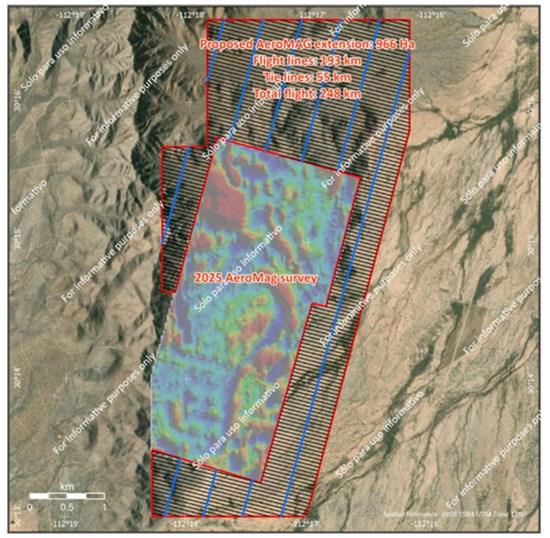
Figure 1: Map showing flight lines (black) and tie lines (blue) relative to the 2025 Aeromagnetic survey data, now expanded to provide broader property coverage.
To view an enhanced version of this graphic, please visit:
Path Forward to Drilling
The aeromagnetic data is being integrated with the property-wide structural reinterpretation, surface and underground sampling, and the up-coming IP survey to finalize drill targets. With permits in hand, site access secured, and a drill contractor and geophysical service provider contracted, Questcorp and Riverside remain on track for drill mobilization at the La Union Project in the coming weeks.
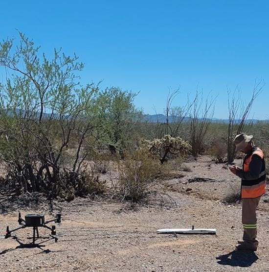
Plate 1: Drone operator conducting airborne magnetometer surveying at La Union, Sonora.
To view an enhanced version of this graphic, please visit:
Qualified Person
The technical content of this news release has been reviewed and approved by R. Tim Henneberry, P. Geo (BC), a Director of the Company and a Qualified Person under National Instrument 43-101 - Standards of Disclosure for Mineral Projects.
About Questcorp Mining Inc.
Questcorp is engaged in the business of the acquisition and exploration of mineral properties in North America, with the objective of locating and developing economic precious and base metal properties of merit. The Company holds an option to acquire an undivided 100-per-cent interest in and to mineral claims totalling 1,168.09 hectares comprising the North Island Copper property, on Vancouver Island, B.C., subject to a royalty obligation. The Company also holds an option to acquire an undivided 100-per-cent interest in the mineral claims totalling 2,520.2 hectares comprising the La Union project located in Sonora, Mexico, subject to a royalty obligation.
ON BEHALF OF THE BOARD OF DIRECTORS,
Saf Dhillon
President & CEO

Legal Disclaimer:
MENAFN provides the
information “as is” without warranty of any kind. We do not accept
any responsibility or liability for the accuracy, content, images,
videos, licenses, completeness, legality, or reliability of the information
contained in this article. If you have any complaints or copyright
issues related to this article, kindly contact the provider above.
Most popular stories
Market Research

More Story


Comments
No comment