


Golden Pursuit Resources Announces Completion Of The 2025 Exploration Program At Gordon Lake Project, NWT
| DAF VEIN (WEST BAY) |
| 1946 (Zolata Yellowknife Mines): Woolgar and Wonnacott staked the property. Zolata Yellowknife Mines optioned the property, performed trenching and 6700 feet of drilling. |
| 1947 (McAvoy): Woolgar and Wonnacott along with J. McAvoy installed a small mill and hand cobbed vein material to produce 50 ounces of gold from 18 tons (2.77 oz/ton). |
| 1948 (West-Bay Yellowknife Mines Ltd.): Acquired the property and a larger mill was installed. Further trenching, drilling, and milling produced 221 oz of gold, and 29 oz of silver from 289 tons of rock. |
| 1958 (Consolidated Northland Mines Limited): Sampling program |
| 1967 (Precambrian Mining Services Limited.): Evaluation Report |
| 1977 (Reed and Doucette): Hand cobbed and milled ore, recovering 27 fine ounces of gold. |
| 1981-1982 (Black Ridge Gold Ltd.): Black Ridge drills 21 holes totaling 420 meters. Several holes hit very high values: 82-03 (4.536 oz over 3 feet), 82-04 (3.192 oz over 3 feet), and 82-05 (9.876 oz over 3 feet). Estimated that to a down dip depth of 64 feet there is a total of 814 tons of ore at 4.21 oz/ton (3400 oz). |
| 1984 (Cruiser Minerals): Drill program under an option agreement, with 44 drillholes totaling 1635m. Calculated an ore shoot 60 feet long by 5 feet wide, averaging 0.888 oz/ton to a depth of 300 feet. (5000 tons at 30.4 g/ton). |
| 1987 (Blackridge and Cruiser Minerals): 400 meters drilled. |
| 1989-1990 (New Era Development and Cameron Mining): 5,540 tonnes bulk sampling. Reported grade of 19 g/t. Over half was processed by Discovery Mine. |
| 2020 (Golden Pursuit Resources Ltd.): Acquired the property. |
| 2021 (Golden Pursuit Resources Ltd.): LiDAR survey, prospecting, and rock sampling (Vivian and Bocking, 2022). |
| 2023 (Golden Pursuit Resources Ltd.): Compilation of historic work and geological mapping (Prior et al., 2023; Prior and Schmidt, 2023). |
Table 2. Exploration history highlights of significant mineral occurrences outside the southern Gordon Lake area. Part 2. Occurrences within the Murray Lake and Myrt Lake properties.
| MURRAY LAKE |
| 1937-1940 (Cominco Limited): Extensive exploration work on the "Pan" claims, including more than 110 trenches, shallow diamond drilling, and two small shafts (8'X6' and 6'X5') completed, with gold showings of 310.9 g/t over 0.91 m and channel samples of 15.55 g/t Au (with veins up to 298.56 g/t Au). |
| 1957-1960 (Alex Mitchell): Staked the "Bairn" claims and reported favourable horizons intersected by 5 drillholes. |
| 1972 (North Star Mines Ltd.): Report on the MSSL claims, which cover the Pan and Bairn claims. The host rock bordering the trenches was found to be auriferous. |
| 1981 (Five Star Resources Ltd): Detailed mapping and sampling immediately south and southeast of the Murray Claim, with the intent to estimate the size and number of gold-bearing veins and determine the structural setting of the veins. |
| 1982 (Hidden Lake Gold Mines Ltd): Limited geological mapping, sampling and prospecting. A quartz vein zone was shown to contain high grades of gold mineralization with gold values up to 3.6 ounces of gold/ton across 1.5 feet in width in a vein with a length of about 30 feet. |
| 1981 (Dale Christensen): 26 shallow drillholes. The best result was 1.308 oz/ton gold (Christensen, 1985). |
| 1985 (Henderson): Mapped the Yellowknife-Hearne Lake Area at a scale of 1:250,000. *Reported RC assay results in Figure 3 presented here are historical, non-compliant with NI-43 guidelines, and are not being used as current. |
| 1994 (Brophy): Described the structure and geochemistry of vein-hosted gold in Burwash turbidites in the area. |
| 2003 (Dahrouge Consulting): Staked the "Murray" claim and optioned to Evolving Gold Corp. |
| 2008 (Triple Dragon): Dahrouge Consulting, on behalf of Triple Dragon, completed geologic mapping and prospecting within the Murray claim. A total of six trench areas were outlined, and chip samples were collected, resulting in 198 samples that were analyzed. The most promising result is from a quartz vein sample in Area A, which assayed 187.71 g/T Au over a 0.25 m length. |
| 2020 (Golden Pursuit Resources Ltd.): Acquired the property. |
| 2021 (Golden Pursuit Resources Ltd.): LiDAR survey, prospecting, and rock sampling (Vivian and Bocking, 2022). |
| 2024 (Golden Pursuit Resources Ltd.): Initial assessment, preliminary structural mapping and rock sampling (Field report, 2024). |
| MYRT LAKE |
| 1938-1939 (Dome Mines Limited): Extensive work included trenching, diamond drilling, and bulk sampling. |
| 1959 (Sam Otto): Staked the "Myrt" claims. |
| 1959 (Walter Temawski): Staked the "WT" claim group. |
| 1938-1974 (Precambrian Mining Services): Surface rock trenching (736 feet in 33 trenches), surface diamond drilling (8226 feet in 65 holes), surface geological mapping. |
| 1974 (Cameron Holdings Limited): Decline of 466 feet, and 405 feet of drifting and crosscutting along the #1 vein. 3,650 feet of underground drilling in 15 drillholes. A total of 3,000 tons of ore grading 0.11oz/t was mined and stockpiled. Ore reserves were estimated to be 25,275 tons grading 0.22 oz Au/ton down to 125'. |
| 1984 (Ryan Energy): 10 drillholes (5,585 feet) verified that the #1 and #3 veins continue to the northwest and at depth below 500 feet. |
| 1987-1989 (William Knutsen): Acquired the property and reported the rehabilitation of the decline. Knutsen (1987) calculated a minable resource to a depth of 110' of 17,510 tons grading 0.35 oz Au/ton, containing 6,132 oz Au. *Reported resources presented here are historical, non-compliant with NI-43 guidelines, and are not being used as current. |
| 1992 (William Knutsen): Processed 2,152 tons of gold at Yellowknife Giant Mine, with 732 oz Au recovered at a grade of 0.36 oz/t and 86% recovery rate. |
| 2020 (Golden Pursuit Resources Ltd.): Acquired the property. |
| 2021 (Golden Pursuit Resources Ltd.): LiDAR survey, prospecting, and rock sampling (Vivian and Bocking, 2022). |
2025 Exploration Program
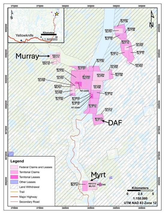
The 2025 exploration program on the Gordon Lake Project (Figure 1) was designed to build on historical high-grade results and mine operations, where sampling and drilling intersected significant gold mineralization. Planned, detailed litho-structural mapping and rock sampling helped to understand better the structural-geochemical relationships associated with gold mineralization. Recent targeted exploration efforts have focused on delineating targets, refining the geological model, and planning drillholes for the subsequent drilling campaigns. Further drilling will focus on both confirmation and step-out drilling to enhance geological understanding and to test new targets identified through geophysical and geochemical surveys.
The 2025 exploration program was divided into three phases: the first phase, which included initial geological mapping and sampling for modelling purposes at Myrt Lake (Figure 2); the second phase at Murray Lake (Figure 3); and the third phase at the DAF properties.
- Litho-structural mapping and extension of known mineralized zones: Initial litho-structural mapping and rock sampling on Murray Lake and Myrt Lake to understand controls on mineralization and start to build a geological model for these deposits, including historic data. Detailed litho-structural mapping and rock sampling were integrated with geophysical surveys and geological models at DAF property to expand on historic work, update and refine the geological model, and drillhole planning.
Litho-Structural Mapping and Sampling Program
Detailed litho-structural mapping, as well as surface rock sampling, were conducted over the entire three properties. The objective was to understand the structural and geochemical controls on mineralization. Rock sampling was designed to fill gaps in historical data and provide a more detailed understanding of gold distribution near high-grade zones, thereby refining future drillhole planning.
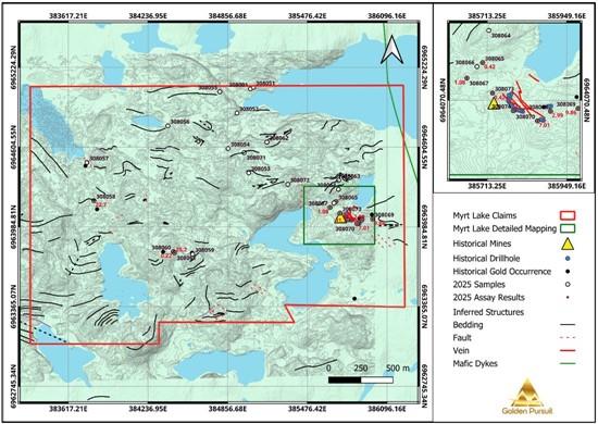
Figure 2. 2025 Sampling at Myrt Lake Property.
To view an enhanced version of this graphic, please visit:
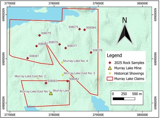
Figure 3. 2025 Sampling at Murray Lake Property.
To view an enhanced version of this graphic, please visit:
References
- Christensen, D, 1985. Rotary Drilling and Sampling, Murray Lake, Assessment Report at NTGS #081941. 4 p. Knutsen, W. G., 1987. Summary Report and Ore Reserve on the 'WT' Gold Property, Myrt Lake, NWT. Prepared for Westfort Petroleums Ltd. Precambrian Mining Service Ltd. Prior, G.; Schmidt, N., 2023. Field Report. Exploration on the Gordon Lake Property. Dahrouge Geological Consulting Ltd. Prior, G.; Schmidt, N.; Gorham, J., 2023. Summary Report on the Gordon Lake Property. Including: Burnt Island, Camlaren, H Vein, 31 Vein, May Island, Kidney Pond, Lynk, Murray Lake, Myrt Lake, Storm, Goodrock, and Vaydik mineral occurrences. Northwest Territories, Canada. Dahrouge Geological Consulting Ltd. Vivian, G; Bocking, N., 2022. Technical Report. South Gordon Lake Property, Northwest Territories, Canada. Prepared for Golden Pursuit Resources Ltd. Aurora Geosciences. Vivian, G, 2021. Technical Report. South Gordon Lake Property, Northwest Territories, Canada. Prepared for Golden Pursuit Resources Ltd. Aurora Geosciences.
Community Engagement
Golden Pursuit collaborates with First Nations organizations on whose traditional territories its projects are located, as well as with the Government of the Northwest Territories, to advance their strategic interests and discuss opportunities to support community initiatives. The Company looks forward to continuing to work with local and regional First Nations in all its future exploration programs.
About the Gordon Lake Project
The Gordon Lake Project, about 80-90 km northeast of Yellowknife, NWT, covers 6,850 hectares and includes 18 territorial claims, 13 federal claims, and five historic mining leases-all fully owned by Golden Pursuit. The site features multiple gold showings with a history of exploration and mining dating back to 1937 and continuing into the late 1980s. Located in the Slave Structural Province of the Canadian Shield's Archean granite-greenstone craton, the property hosts gold-bearing quartz veins and breccia zones primarily in Burwash Formation metaturbidite rocks of the Yellowknife Supergroup.
About Golden Pursuit Resources
Golden Pursuit Resources focuses on gold exploration and fully owns deposits and prospects in the Northwest Territories, Canada, and Nevada, USA, with only royalty obligations on some purchased claims in the NWT. The Gordon Lake project holds active land and water permits until 2030, supporting exploration and development. The company owns 11 properties with histories of mining and exploration dating back to the 1930s, including five classified as "former producers" by the NWT government. It has conducted extensive work at Gordon Lake since 2021. Further details are available at .
Qualified Person
The technical information in this news release has been reviewed and approved by Cleber Peralta, COO and Director of the Company. Cleber Peralta is a Professional Geoscientist (P.) registered with the Engineers and Geoscientists of British Columbia (EGBC) and a "Qualified Person" with respect to NI 43-101. The QP supervised the 2025 Golden Pursuit's exploration program and participated in the litho-structural mapping and sampling campaigns reported here. The Issuer is not treating the historic estimates as current.
On behalf of the Board of Directors
Brian McClay

Legal Disclaimer:
MENAFN provides the
information “as is” without warranty of any kind. We do not accept
any responsibility or liability for the accuracy, content, images,
videos, licenses, completeness, legality, or reliability of the information
contained in this article. If you have any complaints or copyright
issues related to this article, kindly contact the provider above.
Most popular stories
Market Research

- Microgrid Market Growth, Key Trends & Future Forecast 2033
- Nickel Market Estimated To Exceed USD 55.5 Billion By 2033
- Primexbt Launches Empowering Traders To Succeed Campaign, Leading A New Era Of Trading
- Chaingpt Pad Unveils Buzz System: Turning Social Hype Into Token Allocation
- Ecosync & Carboncore Launch Full Stages Refi Infrastructure Linking Carbon Credits With Web3
- Japan Halal Food Market Size To Surpass USD 323.6 Billion By 2033 With A CAGR Of 8.1%
More Story


Comments
No comment