


403
Sorry!!
Error! We're sorry, but the page you were looking for doesn't exist.
Sorrento Resources Identifies 2.25Km Anomalous Copper In Soil Trend, Lord Baron Project, Newfoundland
(MENAFN- Newsfile Corp)
Vancouver, British Columbia--(Newsfile Corp. - October 14, 2025) - Sorrento Resources Ltd. (CSE: SRS) (OTCQB: SRSLF) (the "Company" or "Sorrento") a Canadian exploration company focused on the acquisition, exploration, and development of mineral projects in Atlantic Canada, is pleased to announce the results of the large scale soil geochemical sampling from its 100% owned Lord Barron Property located in Newfoundland, Canada.
Alex Bugden, P. Geo., CEO, President and Qualified Person of Sorrento Resources Ltd., commented, "We are very excited with the results of our summer soil sampling program. To have a soil anomaly over 2km in strike length is very promising and provides us with an area of focus for geophysical surveys and diamond drilling. In addition, the strong correlation between the soil anomalies, geological structures, and historical geophysical anomalies validates soil sampling as an appropriate method of exploration for the property. The historic drilling being oriented away from the heart of the soil anomaly is also very intriguing."
Highlights:
- Several trends of anomalous copper mineralization identified (up to ~2.25km in strike length) Soil anomalies are coincident with geological structures and historical geophysical anomalies Historical drilling is oriented away from soil anomalies 1,005 soil samples collected over four separate grids Largest soil sample program ever undertaken on the property 101 samples are considered anomalous in copper (>102.6 ppm Cu, 90th percentile) 51 samples are considered anomalous in gold (>23.8ppb Au, 95th percentile)
Little Bay Head Grid
Several trends of anomalous copper mineralization have been identified with one having a strike length of ~2.25km and a width of up to ~175m. The anomalies identified are coincident with mapped geological structures. Locally, their are also overlapping historical geophysical anomalies. Moreover, the historical drilling appears to be drilling away from the anomalous soil trend. The Little Bay Head Grid consisted of 667 soil samples at an approximate spacing of 150x50m. This gird completely overlaps four historic soil sampling grids. A total of 77 samples are considered anomalous in copper (>102.6ppm) with the highest value being 2,140ppm Cu. There are 34 samples considered anomalous in gold (>23.8ppb) with the highest value being 223ppb Au.
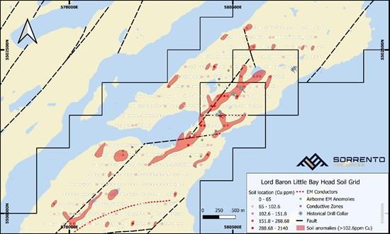
Figure 1.1 Completed Little Bay Head soil grid with copper results (ppm) displayed with graduated symbology.
To view an enhanced version of this graphic, please visit:
Ferndale and Swatridge Grid
An anomalous area approximately 750m x 500m which is open to the south and to the east has been identified. The Ferndale and Swatridge Grid consisted of 86 soil sample at a spacing of approximately 100x250m. The grid covers the Ferndale mineral occurrence and is just to the east of the Swatridge mineral occurrence. In addition, it overlaps an east-west fault structure which locally has anomalous copper in historical stream sediment samples. This was the first soil sampling program in the immediate area. There are 8 samples considered anomalous in copper (>102.6pm Cu) with the highest value being 731ppm Cu. There are 6 samples considered anomalous in gold (>23.8ppb) with the highest value being 159ppb Au.
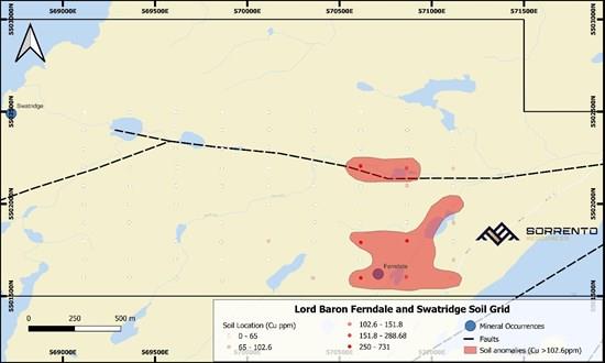
Figure 1.2 Completed Ferndale and Swatridge soil grid with copper results (ppm) displayed with graduated symbology.
To view an enhanced version of this graphic, please visit:
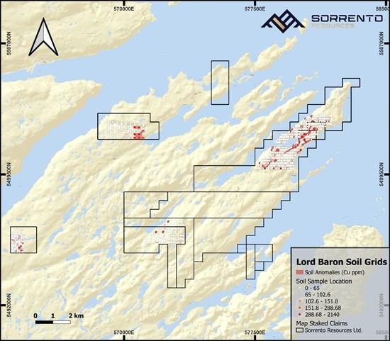
Figure 1.3 Overview of all completed soil grid on the Lord Baron property showing copper results.
To view an enhanced version of this graphic, please visit:
About the Lord Baron Project
The Lord Baron Project is located on the Springdale peninsula, Newfoundland and Labrador near the towns of Springdale, Little Bay, and Beachside. The region has a rich mining history and is host to a skilled workforce, several diamond drilling contractors, a NI-43-101 compliant assay lab, and mining equipment and parts suppliers. In addition, it is adjacent to deep water ports, industrial hydroelectric power supply, and is in proximity to the Nugget Pond mill.
The Project consists of 15 individual mineral licenses made up of 256 individual claims for an area of 6,400ha. The Project is predominately underlain by rocks of the Lush's Bight Group of the tectonostratigraphic Dunnage Zone of the Appalachian Orogen. The Lush's Bight Group is a Cambro-Ordovician sequence of ophiolitic metavolcanic rocks representing a portion of the oceanic crust of the proto-Atlantic Ocean, the Iapetus Sea. The group has been metamorphosed to greenschist facies and has undergone extensive faulting related to the initial formation of oceanic crust as well as the Taconic and Acadian Orogenies.
The Lush's Bight Group contains more base metal sulphide showings per square kilometer than any other group of rocks in Newfoundland. The showings typically occur in an envelope of chlorite schist.
Qualified Person
Alex Bugden, P. Geo., a Qualified Person in accordance with National Instrument 43-101, has reviewed and approved the technical information contained in this press release.
About Sorrento Resources Ltd.
Sorrento Resources is engaged in acquisition, exploration, and development of mineral property assets in Canada. The Company's objective is to locate and develop economic precious and base metal properties of merit in including the Wing Pond, Lord Baron, The PEG lithium project, and the Harmsworth (VMS) project all located in Newfoundland.
On Behalf of The Board of Directors,
SORRENTO RESOURCES LTD.

Legal Disclaimer:
MENAFN provides the
information “as is” without warranty of any kind. We do not accept
any responsibility or liability for the accuracy, content, images,
videos, licenses, completeness, legality, or reliability of the information
contained in this article. If you have any complaints or copyright
issues related to this article, kindly contact the provider above.
Most popular stories
Market Research

More Story


Comments
No comment