


403
Sorry!!
Error! We're sorry, but the page you were looking for doesn't exist.
C3 Metals Geophysical Program Significantly Enhances Khaleesi Copper-Gold Drill Target, Peru
(MENAFN- Newsfile Corp)
Toronto, Ontario--(Newsfile Corp. - August 6, 2025) - C3 Metals Inc. (TSXV: CCCM) (OTCQB: CUAUF) ("C3 Metals" or the "Company") is pleased to announce that recently completed ground-based geophysical surveys have identified large-scale anomalies coincident with high tenor soil geochemistry on its 100% owned Khaleesi copper-gold project ("Khaleesi or the "Project") in Southern Peru.
Magnetic ("Mag"), Induced Polarization ("IP") and MagnetoTelluric ("MT") anomalies coincide with a recently defined high-grade copper-molybdenum in soil anomaly measuring 1,900m by up to 650m and a high-grade copper-zinc in soil anomaly measuring 470m by 400m (see press release dated February 19, 2025). A maiden 14-hole, 6,000m maiden diamond drill program is anticipated to commence during Q3 2025.
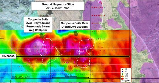
Figure 1: Khaleesi MVI Magnetic Inversion: Amplitude of magnetization (800m depth slice), showing two large magnetic anomalies beneath high tenor copper soil anomalies.
To view an enhanced version of this graphic, please visit:
Dan Symons, President and CEO, stated, "Khaleesi is a highly compelling, undrilled copper-gold mineralized skarn, porphyry prospect in a world-class Porphyry-Skarn belt. Results of the IP, Mag and MT surveys provide invaluable information for realizing the large-scale potential of the hydrothermal system at Khaleesi. We now have a robust dataset to optimally target both the porphyry and skarn style copper mineralization. Importantly, IP and Mag survey data also confirms large anomalies continue beneath and proximal to an area of glacial till cover where there is no outcropping rock at surface. With multiple large copper mines within 45km of Khaleesi, we have reason to be excited to move into the first ever drilling program for the project."
Highlights of the Khaleesi Exploration Program to Date
- The Mag survey confirms a large, near-surface magnetic body that separates into two bodies at depth. This Mag anomaly is coincident with IP chargeability and resistivity anomalies and areas with high copper geochemistry in soils (Figure 1). The IP survey defined two discrete near-surface IP chargeability anomalies with coincident resistivity anomalies , which extend to the maximum depth for this IP survey reliability of ~600 vertical metres (Figure 2).
- Porphyry Copper Target - coincident IP chargeability and resistivity high anomalies positioned beneath an 800m by 400m copper-molybdenum in soil anomaly averaging 950ppm copper where porphyry-style copper mineralization has been mapped at surface. Copper Skarn Target - IP chargeability and coincident resistivity low anomalies correlate with a 470m by 400m copper-zinc soil anomaly averaging 1,260ppm copper that is open along-strike to the north, south and to depth. For reference, copper in soils at or above 300ppm is considered anomalous and represents high priority target areas for further exploration.
- Outcrop samples assayed up to 2.82% copper, 6.0 g/t gold, 57.7 g/t silver and 403 ppm molybdenum (see press releases dated October 22, 2024 and January 8, 2025).
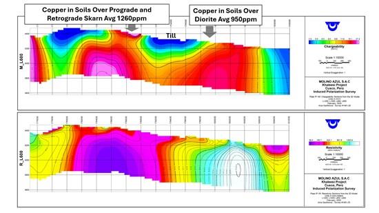
Figure 2: Vertical section chargeability (top) and resistivity (bottom) plot of 2025 IP survey line 600N (shown in Figure 1), looking to the north. The chargeability and resistivity anomalies have never been drill tested by C3 Metals or historically and correlate well with surface copper geochemistry.
To view an enhanced version of this graphic, please visit:
Grid soils defined a 470m by 400m wide copper-zinc in soil anomaly, with soils averaging 1,260ppm copper and 450ppm zinc. Grid soils also defined a significant copper-molybdenum anomaly, which extends for over 1,900m by up to 650m; two discrete zones average 950ppm and 650ppm copper, respectively (Figure 3). Soil sampling also covered a 1.3 sq km area with a thin glacial till cover, varying from less than 1m to 15m in thickness. Glacial till appears to conceal interpreted extensions of the skarn and porphyry mineralized zones. The geophysical data supports the interpretation of the connection of these zones beneath the till occurrence.
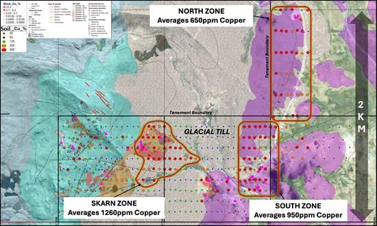
Figure 3: Khaleesi map showing three well defined zones of pervasive copper-in-soil geochemistry. Also showing glacial till zone that appears to conceal mineralized rock below.
To view an enhanced version of this graphic, please visit:
Khaleesi is located 8km west of the Company's Jasperoide Project, where the Company confirmed 13 skarn prospects along a 28km iron-skarn belt. Montana de Cobre ("MCZ") is the first of these skarns the Company systematically drill tested, yielding a near surface Measured and Indicated Mineral Resource of 51.9 million tonnes at 0.50% total copper and 0.20 g/t gold for 569.1 million pounds of copper and 326,800 ounces of gold 1 .
Khaleesi represents a rare opportunity to explore an undrilled copper-gold mineralized skarn, porphyry and epithermal prospect on the world-class Andahuaylas-Yauri Porphyry-Skarn belt. The Company has strategically amalgamated a significant mineral concession package of over 31,000 hectares within 45km of the large Las Bambas (MMG) and Constancia (Hudbay Minerals) copper mines. Several major and intermediate mining companies hold mineral concessions surrounding C3 Metals' mineral concession package and in the district (Figure 4).
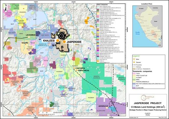
Figure 4: Regional map showing C3 Metals' mineral concession package in relation to other large-scale operations, development projects and exploration projects.
To view an enhanced version of this graphic, please visit:
Geophysical Survey Program Details
Geophysical surveys completed comprised of a 45.5-line kilometre ground Mag survey (100m-spaced lines), a 24.5-line kilometre IP survey (200m spaced lines) and 14 full tensor stations of MT over the Khaleesi project area. The surveys covered an area of approximately 4.4 sq km and focused on covering an extensive area with outcropping porphyry, skarn, epithermal copper-gold-molybdenum mineralization including the central project area covered by glacial till.
A high-resolution ground Mag survey confirmed a large magnetic body (1,200m by 800m) defined after an MVI inversion and is coincident with two chargeability and coincident resistivity anomalies. The magnetic body splits at approximately 600m to 700m depth, separating into two large cohesive bodies (Figure 1). Each of these magnetic bodies measure approximately 800m by 800m.
The IP survey was highly successful in defining two cohesive chargeability and coincident resistivity anomalies that extend along strike for up to 1,200m and are up to 1,000m in width. These IP anomalies are coincident with the Skarn Zone and South Zone copper in soil anomalies (Figure 2). The chargeability anomalies appear to converge at a depth of 450m beneath the till occurrence.
The MT survey was undertaken to detect basement electromagnetic (EM) conductors and anomalous resistivity zones, which can be indicative of potential copper-gold porphyry systems. The MT survey successfully defined a large body coincident with the IP and magnetic anomalies.
Next Steps
Initial mapping and sampling at Khaleesi defined an alteration footprint spanning 1,500m by 1,000m. Subsequent soil sampling defined multiple large scale and coherent copper-in-soil anomalies located over a significant zone of mapped porphyry-skarn-epithermal styles of mineralization. Newly acquired Mag, IP and MT data, provide further evidence for a sizeable system that appears to connect in the central project area beneath the glacial till occurrence. Based on all data collected to date, the Khaleesi project is ranked highest priority for drill testing.
The Company has designed a 14-hole, 6,000m maiden diamond drill program that will target both the Skarn and South zones as well as beneath an area of glacial till that sits between these zones. The Company anticipates it will commence this maiden drill program during Q3 2025.

Legal Disclaimer:
MENAFN provides the
information “as is” without warranty of any kind. We do not accept
any responsibility or liability for the accuracy, content, images,
videos, licenses, completeness, legality, or reliability of the information
contained in this article. If you have any complaints or copyright
issues related to this article, kindly contact the provider above.
Most popular stories
Market Research

More Story


Comments
No comment