


403
Sorry!!
Error! We're sorry, but the page you were looking for doesn't exist.
Powermax Minerals Completes High-Resolution Airborne Geophysical Survey At The Atikokan Rare Earth Element Property, Ontario
(MENAFN- Newsfile Corp)
Toronto, Ontario--(Newsfile Corp. - November 18, 2025) - Powermax Minerals Inc. ( CSE: PMAX ) ( OTCQB: PWMXF ) ( FSE: T23 ) (the "Company" or "Powermax") is pleased to announce the successful completion of a high-resolution helicopter-borne magnetic and radiometric survey over its Atikokan Rare Earth Element (REE) Property located in northwestern Ontario. The survey was conducted by Geo Data Solutions GDS Inc. (GDS) of Laval, Québec.
Survey Overview
The survey, comprised a total of 1,409 line-kilometres of high-resolution magnetic and gamma-ray spectrometric data acquisition. Flight lines were spaced at 50 metres, with tie lines at 500 metres, providing detailed coverage for geological and structural interpretation. The Eurocopter Astar 350BA+ helicopter operated at an average terrain clearance of 44 metres, maintaining tight drape control for optimum data quality. All data acquisition, calibration, and processing were completed according to the specifications of Natural Resources Canada (NRCan) and the International Atomic Energy Agency (IAEA) airborne gamma-ray spectrometry standards.
Survey Objectives and Quality
The survey's primary objectives were to refine structural and lithological interpretations, delineate magnetic trends, and identify zones of elevated potassium, thorium, and uranium signatures - potential indicators of lithological changes or mineralized systems within the Atikokan metasedimentary belt intruded by massive biotite granites.
All field and processing work met contract specifications. GDS reports that magnetic noise levels were well within acceptable limits, GPS positioning and drape-following performance were of high accuracy, and gamma-ray spectrometry data calibration (potassium, uranium, thorium) yielded consistent and reliable results.
Data Processing and Deliverables
Post-flight data processing was performed using Geosoft Montaj and Praga NASVD software to enhance signal-to-noise ratio and produce high-fidelity datasets. Deliverables include full digital databases, GeoTIFF maps, and a digital terrain model at 1:30,000 scale (NAD83 UTM Zone 15N). The Company will further process the data and integrate the survey results with historical and current geological, geochemical, and structural datasets to define new exploration targets for follow-up field work.
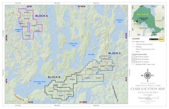
Figure 1: Atikokan Claim Location Map
To view an enhanced version of this graphic, please visit:
Management Comment
Paul Gorman, CEO of Powermax Minerals Inc., commented:
"Completion of this high-resolution airborne survey marks a major step forward in advancing our Atikokan REE Property. The quality of the data is excellent and will allow us to enhance our understanding of the structural framework that controls mineralization in this underexplored part of the Atikokan metasedimentary belt. We look forward to integrating these geophysical results with ongoing geological interpretation and ground follow-up work."
Next Steps
The Company will now undertake a comprehensive processing and interpretation of the magnetic and radiometric datasets in conjunction with historical mapping and recent sampling / geological mapping program results. This integrated approach will guide for the next phase of exploration, including trenching and diamond drilling if required over prospective anomalies.
Qualified Person
The technical information contained in this news release has been reviewed and approved by Afzaal Pirzada, P.Geo., who is a director of the Company and a Qualified Person under National Instrument 43-101 - Standards of Disclosure for Mineral Projects.

Legal Disclaimer:
MENAFN provides the
information “as is” without warranty of any kind. We do not accept
any responsibility or liability for the accuracy, content, images,
videos, licenses, completeness, legality, or reliability of the information
contained in this article. If you have any complaints or copyright
issues related to this article, kindly contact the provider above.
Most popular stories
Market Research

More Story


Comments
No comment