(MENAFN- Brazil-Arab News Agency (ANBA))
São Paulo – Sudan was the object of study of scientists trying to understand how the desertification process takes place. Ricardo Martinez Garcia, now a professor at the Institute of Theoretical Physics at the State University of São Paulo ( Unesp ) and associated researcher at ICTP-SAIFR is one of the researchers of a study started by Michiel P. Veldhuis of the Leiden University in the Netherlands and published on scientific journal Ecography. Now at Unesp, Garcia continues to work in similar topics. ICTP-SAIFR is the South American branch of the international center for physics.
The study aimed at testing in an empirical way a theoretical model that associates the formation of vegetation patterns in arid ecosystems to issues such as lack of water resources and local environmental health. The theory said that regions showed a pattern during the desertification process. First with“holes” amid the vegetation, then a“labyrinth” with more gaps of soil in between plants, finally with vegetation being formed only on certain“dots”.
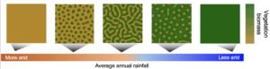
The patterns that scientists can see with a mathematic model. Green regions indicate the presence of vegetation.
Sudan had been chosen in a previous study by Vincent Deblauwe for the first stage of the work, which included a pattern classification in the Arab country. In this new study, the analysis by Veldhuis was based on remote monitoring. Regions studied are near locations such Muglad, Al-Fulah and Babanusa.
Environment equations
The line of research use resources such as equations to be able to analyze the environment.“We've developed mathematical models based on tools of physics and translated them to explain environmental systems,” Garcia pointed out.

Researcher Veldhuis of Leidan University in the Netherlands
At this stage, a computer algorithm uses data such as rain precipitation and vegetation in that particular environment to analyze how the shapes of patterns are created.“We describe these processes with equations, then the question becomes how important theses processes are, what is going to happen in 200 years? We always try to keep the conversation on theoretical mathematical models and real data analysis to confirm if we are walking if not the right, the less wrong path.”
Then, satellite images are factored in to confirm the math. Between the library he created with images of how the vegetations are distributed in this region of Sudan and a computer algorithm, Veldhuis manage to classify the change in this pattern.“And he believed the shape of the pattern changes in the same way the model predicts. Thus, less humid regions have a dot pattern, while more humid regions have hole patterns,” the Unesp professor exemplified.
As the desertification process takes a very long time to happen, the solution was using images from different regions. The territorial area chosen in Sudan includes locations that are more humid and others that are dryer.“What we do is tracking the precipitation gradient from north to south. Then, instead of looking at the time frame, we look at the space frame. Of course, this has some limitations but is a way of handling it,” he said.

A major part of Garcia's meetings with his team at Unesp took place online during the pandemic
After confirming the vegetation pattern model, the researcher set out to verify if the changes in vegetation are really due to climate issues. Other tool used by the scientists to this end was the remote sensing, which uses data to show the level of vegetation in each area and can analyze shorter periods like rain seasons or dry seasons in the same region.
By doing this they managed to chart a time series with the vegetation level over time.“What we did in this job was analyzing these time series to see how the ecosystem health gets worse as the shape of the pattern changes, indicating that this change is in fact accompanied by the approach of a potential desertification in the region,” he explained on one of the overall findings of the study.
South America
The scientist now aims at producing content on arid regions of Brazil and South America.“The biodiversity is always more monitored in Europe and North America than in South America and Africa. Sudan is now very well monitored, but here in South America, there isn't a place where we can test these hypotheses. We conduct a study in a larger scale to only then focus [on an area]”, he explained.
He believes a peculiarity of Sudan is that the studied areas were not heavily influenced by the human being. As for Brazil, one of the possibilities is analyzing places occupied to understand how the vegetation interacts with resources such as climate and human intervention.
Here Garcia has the support of both foreigners and Brazilian and graduate and post-doctoral students. His idea is encompassing both macro analyses using satellite images and micro analysis in research labs.
Translated by Guilherme Miranda
Supplied
Supplied
The post appeared first on .


.jpg)


Comments
No comment