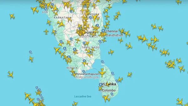
Cyclone Ditwah: 4 Colombo-Bound Flights Diverted To Thiruvananthapuram Airport
Thiruvananthapuram International Airport (TIAL) in a statement said,“Four flights, three from the Middle East region and one from Malaysia, bound for Sri Lanka were diverted to the international airport," on Friday due to bad weather over Colombo.
Earlier, TIAL announced that flight operations will be temporarily suspended for around two hours each day for a week from 27 November in view of scheduled airspace closure for the Navy Operational Demonstration 2025. According to TIAL, flights will not operate between 4 pm and 6:15 pm during the duration of the event.
Also Read | Cyclone Ditwah: Where will the storm hit? IMD warns of 5 days of heavy rain Waterlogging in Tamil NaduLow lying areas in Tamil Nadu witnessed waterlogging in several parts of Thoothukudi as downpour continues.
Also Read | Cyclone Ditwah warning: What the name means and the storm's predicted path Where is cyclonic storm Ditwah?As per India Meteorological Department's (IMD) latest update, the cyclonic storm Ditwah“moved north-northwestwards with the speed of 10 kmph during past 6 hours and lay centered at 0830 hrs IST of today, the 28th November 2025 over the same region, near latitude 8.3°N and longitude 81.0°E, about 40 km southwest of Trincomalee (Sri Lanka), 100 km northwest of Batticaloa (Sri Lanka), 320km south-southeast of Karaikal (India), 430 km south-southeast of Puducherry(India) and 530 km south of Chennai (India).”
Also Read | Cyclone Ditwah warning: What the name means and the storm's predicted pathThe cyclonic storm, which is expected to bring heavy rainfall in southern states, is very likely to continue to“move north-northwestwards across Sri Lanka coast and adjoining southwest Bay of Bengal and reach over southwest Bay of Bengal near North Tamil Nadu, Puducherry and adjoining south Andhra Pradesh coasts by early morning of 30th November.”
The deep depression is expected to bring heavy to very heavy rainfall in Tamil Nadu till November 30 and isolated extremely heavy falls today and tomorrow.
Kanyakumari, Nagapattinam, Pudukkottai, Ramanathapuram, Thanjavur, Thiruvarur, Thoothukkudi, Tirunelveli districts of Tamil Nadu are on IMD's orange alert for heavy rains. Sivaganga, Tenkasi and Virudhunagar are on yellow alert tomorrow.
“Isolated heavy to very heavy rainfall likely over Rayalaseema during 28th November-01st December, 2025, with isolated extremely heavy falls on 30th November; isolated heavy to very heavy rainfall also likely over Coastal Andhra Pradesh & Yanam and Rayalaseema during 28th November-02nd December,” IMD said.
Also Read | 10 Most powerful Nano Banana Pro prompts - Internet is shocked by the resultsPredicting isolated extremely heavy rain in Kerala on 30 November, IMD said isolated heavy rainfall is likely in Telangana on 30 November and 1 December. The prevailing weather system is expected to bring downpour in South Interior Karnataka tomorrow.
Thunderstorm and lightning are also likely in Tamil Nadu and Andhra Pradesh till December 1, in Kerala till 29 November and in Karnataka till 30 November.
Legal Disclaimer:
MENAFN provides the
information “as is” without warranty of any kind. We do not accept
any responsibility or liability for the accuracy, content, images,
videos, licenses, completeness, legality, or reliability of the information
contained in this article. If you have any complaints or copyright
issues related to this article, kindly contact the provider above.


Comments
No comment