


403
Sorry!!
Error! We're sorry, but the page you were looking for doesn't exist.

India- Google Earth's Timelapse feature lets you watch Earth's 40-year evolution
(MENAFN- NewsBytes) So far, Google Earth has served as an indispensable resource for anyone wanting to view any nook and cranny on Earth via satellite imagery. In this article Timelapse touted as biggest update to Google Earth since 2017 Earth Engine processed video for over 2 million hours Timelapses were generated for regions that witnessed significant geographic change Timelapses are curated under change-based categories Earth Engine allows videos to be seen in 3D, downloaded 37 years of data Timelapse touted as biggest update to Google Earth since 2017
Since its launch in 2001, Google Earth has constantly added new features to make the platform more informative. Pixel crunching Earth Engine processed video for over 2 million hours

The company created the world's largest video of Earth on its Earth Engine, a cloud platform for geospatial analysis. Sands of time Timelapses were generated for regions that witnessed significant geographic change
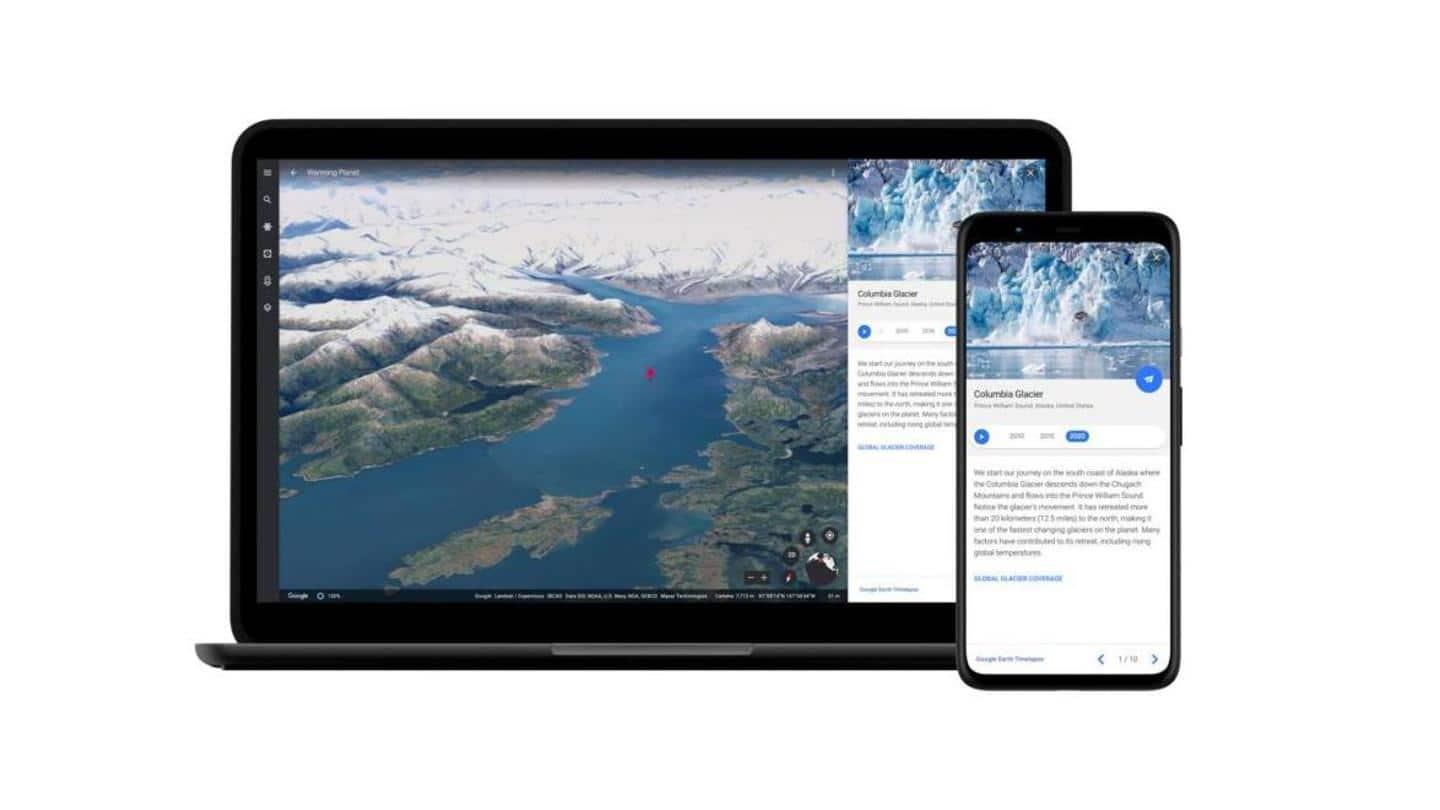
People can use Google Earth to "watch time unfold" via this link ( ) or by navigating to the Google Earth website and clicking the ship wheel button which redirects you to an interactive tour on the Voyager platform. Simplified navigation Timelapses are curated under change-based categories
To simplify navigation, Google Earth has curated the timelapse videos on its website under various categories such as "Changing Forests," "Fragile Beauty" (meandering rivers), "Warming Planet" (polar regions), and "Urban Expansion" (metropolitan development). Immense scope Earth Engine allows videos to be seen in 3D, downloaded

The individual videos on Google Earth Engine can be viewed in either 2D or 3D. Google has graciously provided an option to download each video separately.
Now, in the first major update in four years, Google Earth has added another dimension to its platform—time.
Using the new Timelapse feature , people can view nearly four decades of planetary evolution through data agglomerated from satellites.
The company is calling the Timelapse feature the "biggest update to Google Earth since 2017".
The technology for the Timelapse feature was created in collaboration with experts from Carnegie Mellon University's CREATE Lab . The incorporated data was collected over 37 years using 24 million satellite images.
The company processed a whopping 20 petabytes of satellite images for over two million hours to create a 4.4 terapixel sized video mosaic.
To help you digest that data, it's the equivalent of over half a million videos recorded in 4K.
The timelapse videos have been generated for areas that saw significant geographic change such as metropolitan cities, polar ice caps, and oceans.
Each of the 800+ Timelapse videos has been uploaded to the Google Earth Engine. They can be viewed here ( ) sorted by themes and regions.
It will be interesting to see how scientists, data analysts, and researchers leverage the colossal volume of data that Google Earth has thrown open for public access.

Legal Disclaimer:
MENAFN provides the
information “as is” without warranty of any kind. We do not accept
any responsibility or liability for the accuracy, content, images,
videos, licenses, completeness, legality, or reliability of the information
contained in this article. If you have any complaints or copyright
issues related to this article, kindly contact the provider above.
Most popular stories
Market Research

More Story


Comments
No comment