


403
Sorry!!
Error! We're sorry, but the page you were looking for doesn't exist.
A.I.S. Resources Engages Geo Data Solutions GDS Inc. To Complete Airborne Magnetic And VLF-EM Geophysical Surveys At Its Pocologan Project, New Brunswick
(MENAFN- GlobeNewsWire - Nasdaq) VANCOUVER, British Columbia, May 11, 2026 (GLOBE NEWSWIRE) -- A.I.S. Resources Limited (TSX-V: AIS. OTC PINK: AISSF) (the“Company” or“A.I.S.”) is pleased to announce it has engaged Geo Data Solutions GDS Inc. of Laval, Quebec to complete a high-resolution helicopter-borne magnetic survey and a very low frequency electromagnetic (VLF-EM) survey over the Company's Pocologan Project, located approximately 40 kilometres west of Saint John, New Brunswick. ![Figure1-Proposed Survey Plan]()
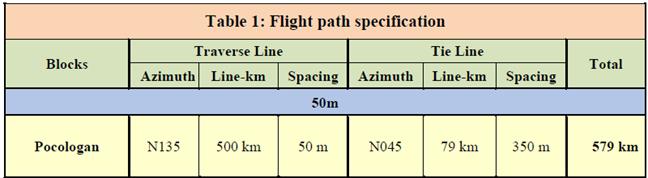
The proposed survey is expected to comprise approximately 579 line-kilometres, including approximately 500 line-kilometres of traverse lines at 50-metre spacing and 79 line-kilometres of tie lines at 350-metre spacing. The survey is designed to provide detailed geophysical coverage across priority target areas and assist A.I.S. in mapping magnetic trends, structural features, lithological contacts, and potential conductive zones that may warrant follow-up exploration.
The survey is expected to be flown using an Astar 350 B2 helicopter or equivalent aircraft, equipped with a high-sensitivity cesium magnetometer, differential GPS navigation, radar altimeter, magnetic base station support, and a multi-channel VLF-EM system. Final survey deliverables are expected to include processed residual total magnetic field data, first vertical derivative magnetic data, digital elevation model data, and VLF-EM profile products. These datasets will be integrated with available geological, geochemical, and historical exploration information to refine target areas for future prospecting, mapping, sampling, and potential drill testing.
Table 1: Survey Details
Marc Enright-Morin, CEO of A.I.S. said,“We are pleased to advance the Pocologan Project with a modern airborne geophysical survey. The survey is intended to improve our understanding of the project's structural and geological framework and to assist in prioritizing targets for follow-up exploration. Pocologan is an early-stage project with multiple prospective target areas, and this work represents an important step in developing a systematic exploration model.”
Figure 1: Proposed survey plan

Legal Disclaimer:
MENAFN provides the
information “as is” without warranty of any kind. We do not accept
any responsibility or liability for the accuracy, content, images,
videos, licenses, completeness, legality, or reliability of the information
contained in this article. If you have any complaints or copyright
issues related to this article, kindly contact the provider above.
Most popular stories
Market Research

More Story


Comments
No comment