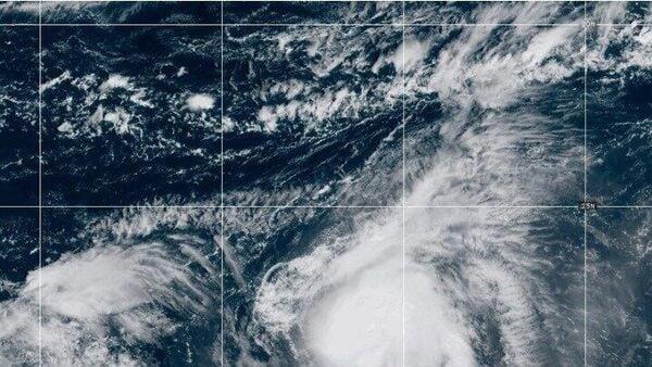
Hurricane Humberto And Imelda Loom Over Bahamas, Bermuda With Strong Winds And Heavy Rain
Humberto was classified as a Category 4 hurricane, with maximum sustained winds reaching 145 mph (230 kph). It was positioned roughly 365 miles (585 kilometers) south-southwest of Bermuda and was moving northwest at a speed of 14 mph (22 kph). A tropical storm watch was in effect for Bermuda , AP reported.
Authorities in the Bahamas shut down most schools on Monday due to mandatory evacuations on certain islands, as Tropical Storm Imelda was predicted to bring heavy rainfall and flooding to the northern Caribbean, the report noted. Flights to and from the islands in the Bahamas were cancelled, with airports expected to reopen after weather conditions improve.
Imelda had sustained winds reaching 50 mph (85 kph) and was moving northward at 9 mph (15 kph). The National Hurricane Center in Miami predicted that the storm would strengthen into a hurricane by Tuesday before moving out into the open ocean.
Also Read | Hurricane Humberto nears Bermuda, Depression Nine expected to become Imelda What is Fujiwhara effect?As per a report by AP, Alex DaSilva, the main hurricane expert for AccuWeather, a private US weather forecasting company, said,“This is really what's going to be saving the United States from really seeing catastrophic rainfall." According to DaSilva, when two storms are close to each other, they can interact through a phenomenon known as the Fujiwhara effect, where they begin to rotate counterclockwise around one another.
He mentioned,“It's a very rare phenomena overall in the Atlantic basin."
Also Read | Hurricane Humberto: Latest path, forecast and preparation tipsA tropical storm warning was issued for parts of the northwestern Bahamas, including Eleuthera, the Abacos, Grand Bahama Island, and nearby keys. Some areas experienced power outages, prompting authorities to close government offices on the affected islands.
Imelda was expected to bring 4 to 8 inches (10 to 20 centimeters) of rainfall to the northwest Bahamas through Tuesday, and 2 to 4 inches (5 to 10 centimeters) to eastern Cuba.
Meanwhile, moisture from Imelda was expected to move into the Carolinas, bringing heavy rainfall through Tuesday morning. The heaviest downpours were forecast to stay near the coast, particularly from Charleston, South Carolina, to Wilmington, North Carolina. Inland cities like Charlotte and Raleigh were expected to receive only 1 to 2 inches (3 to 5 centimeters) of rain, according to DaSilva.
He also noted that the Carolinas could experience wind gusts up to 40 mph, but mainly along the coastline. DaSilva warned that dangerous surf and strong rip currents would persist throughout the week.
(With inputs from AP)
Legal Disclaimer:
MENAFN provides the
information “as is” without warranty of any kind. We do not accept
any responsibility or liability for the accuracy, content, images,
videos, licenses, completeness, legality, or reliability of the information
contained in this article. If you have any complaints or copyright
issues related to this article, kindly contact the provider above.
Most popular stories
Market Research

- Seoul Exchange, One Of Only Two Licensed Platforms For Unlisted Securities, Will Exclusively Use Story To Settle Tokenized Rwas
- Phase 6 Reaches 50% Mark As Mutuum Finance (MUTM) Approaches Next Price Step
- 0G Labs Launches Aristotle Mainnet With Largest Day-One Ecosystem For Decentralized AI
- Solotto Launches As Solana's First-Ever Community-Powered On-Chain Lottery
- Kintsu Launches Shype On Hyperliquid
- Blockchainfx Raises $7.24M In Presale As First Multi-Asset Super App Connecting Crypto, Stocks, And Forex Goes Live In Beta


Comments
No comment