


Recognizing Palestine Doesn't Make It Real
(MENAFN- Asia Times)
There has been a recent rush of countries to formally recognize the state of Palestine. Affirming Palestinian sovereignty marks a historic diplomatic milestone, yet the exact layout of its territory, a central requirement under international law, remains fiercely contested from every hilltop in the West Bank to the ruins of Gaza.
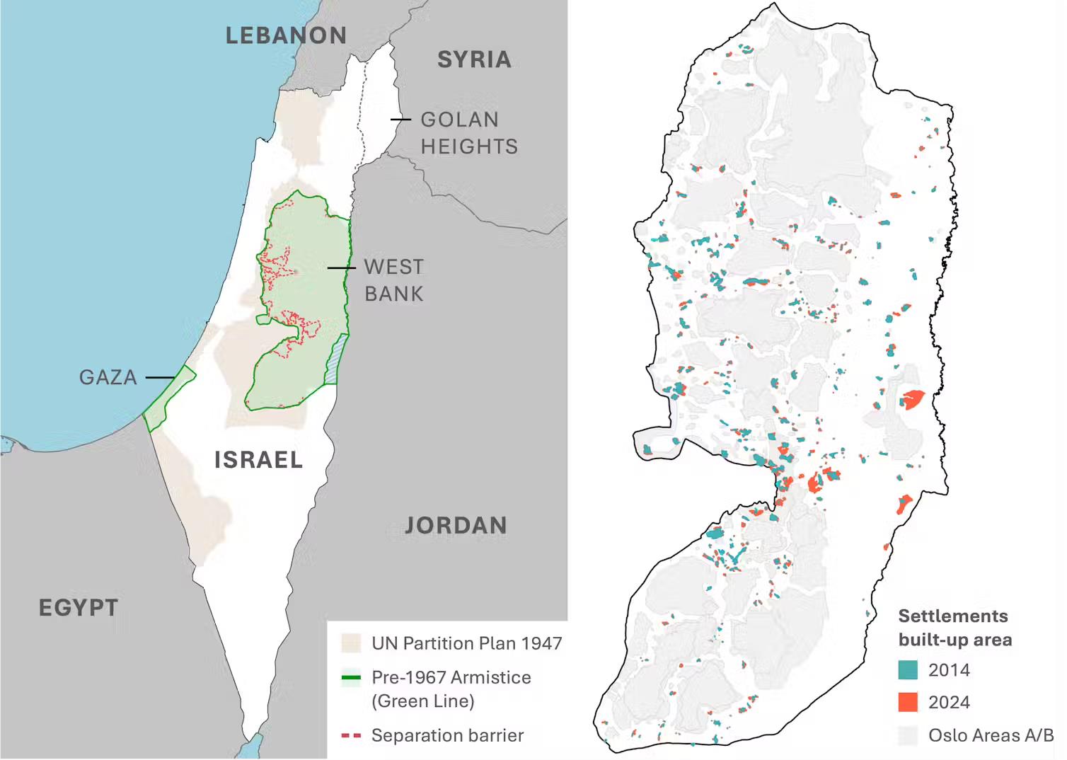
The shrinking map of Palestine. Left: historic borders. Right: settlement expansion in the West Bank. Mallock & Krekel (2025)., Author provided (no reuse) / The Conversation
Building insecurity
To grasp what this moment means, we need to trace how borders have evolved – or dissolved – over Palestine's tumultuous political history. The 1947 UN partition plan had envisioned two semi-contiguous territories for Jewish and Arab states, with Jerusalem as an international city.
But that vision quickly collapsed into the war that led to the establishment of Israel in 1948. Palestinians found themselves confined to the West Bank and Gaza Strip as fully separated territories, demarcated by the“green line” and placed under Jordanian and Egyptian control.
These initial contours remain the internationally recognised basis for Palestinian statehood until today – and are referred to as the“pre-1967 borders.” That year, the Six-Day War saw Israel effectively tripling its territory . It occupied all of the West Bank and Gaza Strip and annexed East Jerusalem.
Israeli settlements immediately began fragmenting Palestine's geography, especially in the West Bank. These settlements are illegal under international law, and in many cases lacked even the government's authorisation.
Yet they faced limited government pushback – and were often directly supported by Israeli authorities. The Oslo Accords later carved the territory into Areas A, B, and C with varying degrees of Palestinian governance.
Following suicide bombings during the second intifada (2000-05), Israel built a separation barrier cutting deep inside the 1967 borders. Six decades on, the West Bank resembles a fragmented archipelago more than a cohesive state territory.
The shrinking map of Palestine. Left: historic borders. Right: settlement expansion in the West Bank. Mallock & Krekel (2025)., Author provided (no reuse) / The Conversation
Building insecurity
In a recent study , my colleagues and I used satellite imagery to show, for the first time, what exactly this does to the West Bank. We tracked all 360 settlements and outposts that existed in 2014 across the following decade.

Legal Disclaimer:
MENAFN provides the
information “as is” without warranty of any kind. We do not accept
any responsibility or liability for the accuracy, content, images,
videos, licenses, completeness, legality, or reliability of the information
contained in this article. If you have any complaints or copyright
issues related to this article, kindly contact the provider above.
Most popular stories
Market Research

- LYS Labs Moves Beyond Data And Aims To Become The Operating System For Automated Global Finance
- Ethereum-Based Defi Crypto Mutuum Finance (MUTM) Raises Over $16 Million With More Than 720M Tokens Sold
- 0G Labs Launches Aristotle Mainnet With Largest Day-One Ecosystem For Decentralized AI
- Yield Basis Nears Mainnet Launch As Curve DAO Votes On Crvusd Proposal
- Lowkick Studio Launches $SHARDS Token On Top Tier Exchanges For Worldshards MMORPG
- Tapbit At TOKEN2049: Reshaping The Crypto Landscape Through Product Innovation
More Story


Comments
No comment