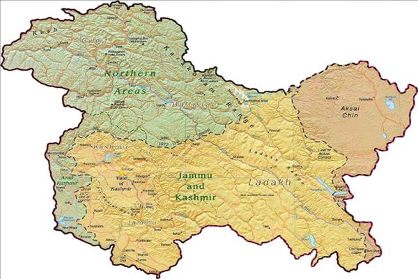
China Removes Map Depicting Kashmir As Part of India
NEW DELHI — China had reportedly removed maps showing Jammu and Kashmir (J & K) and Arunachal Pradesh as part of India from the BRI website during the second Belt and Road Initiative (BRI) Summit which was underway in Beijing.According to a report by India Today, the map was modified as it 'misrepresented' China's stated position on Kashmir and Arunachal Pradesh.
The map was hosted on Chinese government's Ministry of Commerce's website displaying routes under China's flagship Belt and Road Initiative.
The map also incorrectly portrayed India as part of BRI even when New Delhi has boycotted the summit twice. India had boycotted the first summit in 2017.
The map did not clearly distinguish Pakistan-controlled Kashmir which is a core part of the China-Pakistan Economic Corridor (CPEC).
India has expressed strong opposition against the CPEC, an important connectivity project under the BRI, which links the Gwadar Port in Pakistan's Balochistan with China's Xinjiang province.

Legal Disclaimer:
MENAFN provides the information “as is” without warranty of any kind. We do not accept any responsibility or liability for the accuracy, content, images, videos, licenses, completeness, legality, or reliability of the information contained in this article. If you have any complaints or copyright issues related to this article, kindly contact the provider above.
Most popular stories
Market Research

- Manuka Honey Market Report 2024, Industry Growth, Size, Share, Top Compan...
- Modular Kitchen Market 2024, Industry Growth, Share, Size, Key Players An...
- Acrylamide Production Cost Analysis Report: A Comprehensive Assessment Of...
- Fish Sauce Market 2024, Industry Trends, Growth, Demand And Analysis Repo...
- Australia Foreign Exchange Market Size, Growth, Industry Demand And Forec...
- Cold Pressed Oil Market Trends 2024, Leading Companies Share, Size And Fo...
- Pasta Sauce Market 2024, Industry Growth, Share, Size, Key Players Analys...


Comments
No comment