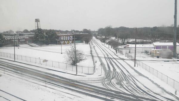
Schools In Georgia And North Carolina Close Or Go Virtual Due To Freezing Temperatures
In Georgia, several schools remain closed or have shifted to digital learning days as the state grapples with recovery efforts. Many local districts have urged caution, highlighting that residual ice from the storm poses risks for morning commuters and school transportation.
North Carolina faces subzero wind chillsNorth Carolina schools are also experiencing delays and closures as frigid wind chills sweep through the region. Morning temperatures dropped to single digits in many areas, with subzero wind chills making travel conditions hazardous.
Districts will continue to monitor conditions and provide updates as the cold snap persists. Parents are encouraged to check school websites and local news outlets for the latest information on closures and schedule adjustments.
Snowstorms, ice, and bitter cold expected through next MondayAccuWeather meteorologists are forecasting an extended period of wintry weather stretching from the Midwest to the Appalachians and Atlantic Seaboard, with multiple rounds of snow and icy conditions expected through Monday. While no single storm is anticipated to be a blockbuster, the cumulative effects could create hazardous travel and bitterly cold conditions.
Clipper storm to hit midwest and Appalachians midweekThe first storm in this sequence, a clipper-style system, will bring light to moderate snow from Wednesday evening to Thursday night. Expected snowfall totals are 1–3 inches, with higher amounts near the Great Lakes and elevated areas of West Virginia and southwestern Pennsylvania. Intermittent snow may extend east of the Appalachians to parts of the Interstate 95 corridor, impacting the mid-Atlantic and New England Thursday afternoon into the night.
Late Week: A complex weather setupFollowing the clipper storm, a more complex system will emerge as Arctic air sweeps southward across the Great Plains and moves eastward.
Rain and Ice: Precipitation will span from the Gulf Coast to the Great Lakes starting Friday. Rain is forecast in the Ohio Valley and mid-Atlantic, but cold ground temperatures could create icy conditions in parts of the Appalachians and Piedmont regions Friday night through Saturday.
Snow along Interstate 70: A wintry mix is possible in the Midwest, with intermittent snow farther north near the Great Lakes and into the Appalachians and northern New England Saturday into Saturday night.
Weekend travel disruptions expectedAccuWeather warns that airline delays will build over the weekend due to deicing operations and weather-related challenges. Road travel may also be hazardous as cold air causes a freeze-up from the Ohio and Tennessee Valleys to coastal Northeast areas Saturday night.
"At this time, most likely snow will have departed Washington, D.C., in time for the Presidential inauguration on Monday, but there may be slippery conditions for those traveling to the nation's capital from Sunday to early Monday morning," cautioned AccuWeather Senior Meteorologist Adam Douty.
Also Read | Oscars 2025 to be cancelled due to LA fires? What we know so far More snow and ice from Sunday to MondayAnother storm system will bring widespread wintry conditions starting Sunday (January 19).
Coastal and Interior Southeast: Snow and ice accumulation could disrupt travel in the Southeast and mid-Atlantic regions, including the Piedmont, Sunday into Sunday night.
Northeast: Snow is likely to continue into Monday morning in New England, with icy roads adding to travel challenges.
Should the storm gain strength, snowfall could extend into the Tennessee and Ohio Valleys, raising the risk of more significant accumulation.
Also Read | The blaze of Los Angeles will be harmful long after the last ember dies out Lake-effect snow to persist in Great Lakes regionPersistent lake-effect snow is expected downwind of the Great Lakes, with some areas potentially receiving feet of snow.
"A storm that swept through the Great Lakes region and brought a round of snow will also kick off another round of lake-effect snow downwind of the lakes over the upcoming days," explained AccuWeather Meteorologist Brandon Buckingham.
Areas such as Michigan's Upper Peninsula may see snowfall rates of 1–3 inches per hour, overwhelming plow trucks and reducing visibility to less than a quarter mile.
Also Read | LA fires: High winds expected; 84,000 could be orderd to evacuate | 5 points Cold Arctic air to intensifyAs the storms subside, Arctic air will dominate, with highs forecast in the 20s in Washington, D.C., by midweek and single digits in Chicago. AccuWeather RealFeel Temperatures may plunge 10–20 degrees below actual readings due to wind gusts of 20–30 mph. Legal Disclaimer:
MENAFN provides the
information “as is” without warranty of any kind. We do not accept
any responsibility or liability for the accuracy, content, images,
videos, licenses, completeness, legality, or reliability of the information
contained in this article. If you have any complaints or copyright
issues related to this article, kindly contact the provider above.


Comments
No comment