

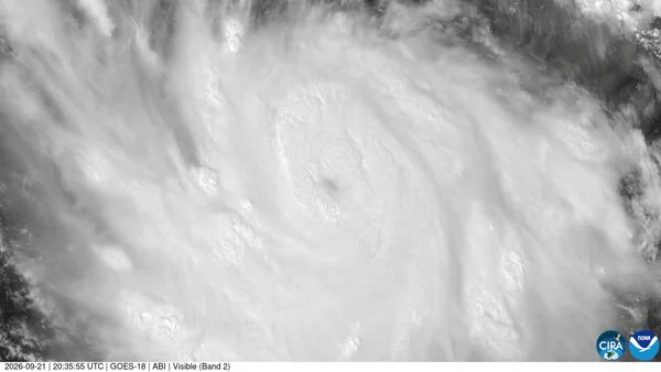
Hurricane Polo Reaches Category 5 Strength: When It Is Likely To Make Landfall And Which Areas To Be Worst Affected?


Polo jumped from Category 1 to the strongest Category 5 classification on the Saffir-Simpson hurricane scale in less than a day. The hurricane was packing sustained winds of around 160 mph (260 kph) and could strengthen further, the NHC said.
Also Read | Trump at UNGA: US President again claims credit for India-Pakistan ceasefire
Despite the expectation that the storm will remain at sea, forecasters warned that Polo could still bring dangerous weather conditions to parts of Mexico, including life-threatening flooding and mudslides.
"The core of Polo is expected to be near the coast of southwestern Mexico during the next few days, although forecast to remain offshore," the NHC said.
The hurricane was also expected to continue strengthening through Wednesday, keeping authorities and residents along the Pacific coast on alert.
Guerrero and Michoacan prepare for heavy rainMexican authorities have stepped up preparations as Polo approaches the country's Pacific coastline. Schools and classes were suspended in several Pacific coast states, including Guerrero and Michoacan, where heavy rainfall was expected to arrive first.
In Acapulco, a popular tourist destination in Guerrero, authorities used loudspeakers along beaches and roads on Monday to warn residents and visitors about the possibility of thunderstorms.
Acapulco remains particularly sensitive to major storms after Hurricane Otis caused extensive devastation in the city in 2023.
"We recommend taking preventive measures at home or at work, checking safety conditions in your home and locating your nearest temporary shelter," they urged.
Also Read | UNGA 2026: Amazon expands secure cloud service to all NATO countries Mexico faces annual cyclone threatMexico experiences tropical cyclones every year along both its Pacific and Atlantic coastlines. The country's cyclone season generally runs from May through November, bringing the risk of strong winds, heavy rainfall, flooding and landslides.
The current season is expected to be particularly active, with weather patterns associated with El Niño playing a role.
El Niño is a recurring climate phenomenon that typically develops every two to seven years. During the event, trade winds that normally blow from east to west weaken temporarily, altering ocean temperatures and atmospheric circulation and potentially influencing tropical storm activity.
Authorities continue to monitor Polo closely as the hurricane moves offshore, with flooding and landslides remaining the main threats even in the absence of a direct landfall.

Legal Disclaimer:
MENAFN provides the
information “as is” without warranty of any kind. We do not accept any
responsibility or liability for the accuracy, content, images, videos,
licenses, completeness, legality, or reliability of the information
contained in this article. If you have any complaints or copyright issues
related to this article, kindly contact the provider above.
Comments
No comment