

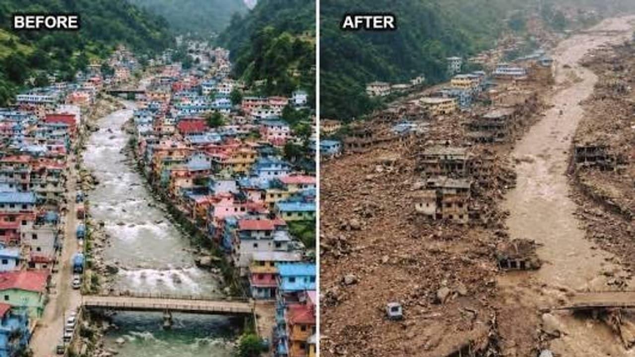
Nepal-Tibet Floods: Before-After Images Show Devastation 469 Dead, 1,400 Missing


Floods and landslides along the Nepal–Tibet border have reshaped whole valleys, with before‐after satellite images showing neighborhoods erased in Devighat, Syabrubesi and Betrabati. At least 469 people are confirmed dead across Nepal and Tibet, and more than 1,400 are missing.
Days earlier, these towns had homes, roads and routine life by the rivers. A sudden surge and slope failures turned them into debris fields, a transformation the imagery captures with stark clarity.
Chinese state media report heavy casualties, and Nepali officials warn the toll could rise as access improves. Severed roads and unstable ground continue to slow operations, and searches are reaching isolated pockets only gradually.
The core disaster zone sits about 64 kilometres north of Kathmandu. Teams are moving in where routes allow, but shifting conditions and fresh falls keep reopening risks and delays.
View this post on InstagramA post shared by Infusion Notes (@infusion_notes)
What the satellite images reveal
In Devighat, the riverside and adjoining housing have been reworked. In Syabrubesi, the line between the main road and homes appears to have vanished. Around Betrabati, broad spreads of sediment and rubble now occupy riverbanks and nearby land.
Images from the Langtang glacier show pronounced surface change. The pictures do more than log losses; they show how quickly a flood and debris flow can overrun an alpine corridor, compounding each hour of the rescue.
View this post on InstagramA post shared by GPlus (@guwahatiplus)
Cause under scrutiny as USGS rules out local quake
Early suspicion fell on an earthquake, but USGS analysis did not confirm a quake in this area. Specialists say glacier collapse, or rapid movement of snow and soil, can unleash sudden torrents; the exact trigger remains unconfirmed.
Persistent rain, unstable slopes and moving debris are complicating the response. Officials fear people remain under rubble, so searches have intensified along riverbanks and within affected settlements as the window for survivors narrows.
View this post on InstagramA post shared by Earth From Satellites (@earthfromsatellites)
For families of the more than 1,400 unaccounted for, uncertainty deepens. The army, local administration and rescue crews are expanding sweeps even as conditions force them to improvise access between breaks in the weather.

Legal Disclaimer:
MENAFN provides the
information “as is” without warranty of any kind. We do not accept any
responsibility or liability for the accuracy, content, images, videos,
licenses, completeness, legality, or reliability of the information
contained in this article. If you have any complaints or copyright issues
related to this article, kindly contact the provider above.
Comments
No comment