


403
Sorry!!
Error! We're sorry, but the page you were looking for doesn't exist.
Powermax Minerals Identifies High-Priority Ree Targets At Atikokan Project, Northwestern Ontario
(MENAFN- Newsfile Corp)
Toronto, Ontario--(Newsfile Corp. - November 10, 2025) - Powermax Minerals Inc. (CSE: PMAX) (OTCQB: PWMXF) (FSE: T23) (" Powermax " or the " Company ") is pleased to announce the results of an integrated geoscientific interpretation completed on its Atikokan Rare Earth Element (REE) Property, located approximately 35 km northwest of Atikokan, Ontario. The study-conducted by Shahab Tavakoli, P.Geo., Geospatial Data Scientist and Geophysicist-integrates geological, geophysical, and geochemical datasets to delineate priority REE exploration targets across Blocks A, B, and C, covering a total of 9,416 hectares in the Thunder Bay Mining District.
The desktop study included historical airborne magnetic (MAG), Bouguer gravity (BG), and radiometric (RAD) data, together with Ontario Geological Survey (OGS) deep lake-sediment geochemistry-to delineate potential zones of elevated REE across the property.
Study Highlights
- Well-defined REE corridor delineated along batholith-gneiss contact: The integration of multiple datasets outlines a structural-geochemical corridor of REE enrichment along the contact between the White Otter Batholith and the Dashwa Gneissic Suite, a setting characterized by steep structural fabrics and fertile lithological contrasts conducive to REE-bearing alteration systems. Strong REE anomalies confirmed in Blocks B and C: The southern blocks returned Total Rare Earth Element (TREE) values from 254 to 1,947 ppm (mean ≈ 616 ppm) in OGS lake-sediment samples, coincident with low gravity, subdued magnetic susceptibility, and elevated Th/K (> 4.5-5.5) and Th/U (> 7.5-8.5) ratios. These attributes delineate a NE-SW trending mineralized corridor, interpreted to host phosphate-bearing, metasedimentary-hosted REE systems genetically linked to calc-alkaline granitic magmatism. Additional localized potential in Block A: Within the interior of the White Otter Batholith, moderately elevated TREE values (339-1,111 ppm; mean ≈ 570 ppm) occur along low-gravity, low-magnetic corridors, reflecting structurally controlled hydrothermal alteration zones and potential small-scale Th-REE-bearing pegmatitic systems.
Ongoing Exploration Program
Powermax has initiated the next phase of exploration, designed to validate and expand upon the desktop study results. The current program includes:
- High-resolution airborne magnetic and radiometric surveys (≤ 100 m line spacing) are now underway to refine the geometry of REE-bearing zones and identify additional structural trends (see Oct 21, 2025, news release); Detailed geological mapping and structural interpretation across the White Otter-Dashwa contact zone, targeting key alteration corridors and shear structures; Systematic surface sampling, including rock and soil sampling, to confirm REE-bearing phases such as monazite, allanite, xenotime, and fluorapatite identified in the desktop review (see Oct 16, 2025, news release); and Integration of new field data with existing regional geophysical and geochemical datasets to prioritize potential drill-ready targets for subsequent exploration phases.
The field results will be incorporated into the ongoing Atikokan REE exploration model, enhancing geological understanding and guiding follow-up work across the most promising zones within Blocks B and C.
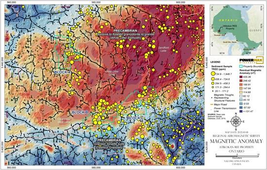
Figure 1: Map Showing Total REE in Lake Sediments and Residual Magnetic Anomaly (nT)
To view an enhanced version of this graphic, please visit:
CEO Comment
"We are very encouraged by the progress at Atikokan," said Paul Gorman, President and CEO of Powermax Minerals Ltd. "The desktop study provided a strong scientific basis for identifying REE-enriched corridors, and our active field program is now expanding on those findings. The integration of ground observations, geochemical assays, and high-resolution geophysics will allow us to rapidly advance toward defining specific targets for detailed follow-up exploration."
About the Atikokan REE Property
The Atikokan REE Property comprises three mineral claim blocks (A, B, and C) covering approximately 9,416 hectares in northwestern Ontario, located 35 km northwest of the town of Atikokan and 188 km west of Thunder Bay. The property is accessible year-round by a network of gravel and logging roads branching from Highways 622 and 11. Geologically, it is situated near the boundary between the Wabigoon and Quetico sub-provinces of the Archean Superior Province-an area known for fertile granitic intrusions, reactive metasedimentary rocks, and favorable structural corridors for REE and lithium-bearing pegmatite mineralization.
Qualified Person
The technical information contained in this news release has been reviewed and approved by Afzaal Pirzada, P.Geo., who is a director of the Company and a Qualified Person under National Instrument 43-101 - Standards of Disclosure for Mineral Projects.

Legal Disclaimer:
MENAFN provides the
information “as is” without warranty of any kind. We do not accept
any responsibility or liability for the accuracy, content, images,
videos, licenses, completeness, legality, or reliability of the information
contained in this article. If you have any complaints or copyright
issues related to this article, kindly contact the provider above.
Most popular stories
Market Research

More Story


Comments
No comment