(MENAFN- Newsfile Corp) Aurania and Metron Find Lost City of Gold in Ecuador
Toronto, Ontario--(Newsfile Corp. - May 31, 2022) - Aurania Resources Ltd. (TSXV: ARU) (OTCBQ: AUIAF) (FSE: 20Q) ('Aurania' of the 'Company') is pleased to report that through a collaboration with Metron Incorporated ('Metron') of Reston, Virginia, USA, the 'lost city' of Logroño de los Caballeros has been found in Ecuador. The site considered to be the ancient gold camp is not on Aurania's concession block, but is downstream, and is exclusively alluvial (placer) gold. No archaeology has been found. Aurania is now on the hunt to find Logroño's source of gold within its Lost Cities - Cutucu Project ('Project') in southeastern Ecuador. The location of Logroño, as inferred by Metron, is supported by a multitude of historical documents as well as geological information collected by Aurania and the increased presence of artisanal miners in the area.
Logroño de los Caballeros was one of seven historic mining areas operating during the time of the Spanish conquistadors in the land that became Ecuador. Its geographic location and that of a second site, Sevilla del Oro, have been lost over time. Aurania's Project is partly based, and is named on the premise, that the two lost cities would be within Aurania's large concession package.
Dr. Keith Barron, President and CEO of Aurania, commented, 'More than four hundred years have passed since Spanish activity at Logroño ceased, and even though many of the records have been lost, what survives is a compelling narrative of gold mining in what would have been one of the most remote and isolated areas on Earth. It is sad that my colleague and mentor, Professor Octavio Latorre, did not live to see the fruit of his many thousands of hours of labor in the archives. To date, we have found many epithermal gold-silver prospects on our concession package, and I believe that this key discovery can ultimately lead us to Logroño's gold source.'
Dr. Lawrence Stone, Chief Scientist of Metron, remarked, 'Metron is pleased to have helped find the historic gold city of Logroño de los Caballeros. The success of this effort is another example of the power of Bayesian search theory, which has been used to find sunken ships and aircraft as well as vessels and people missing at sea. Our success in integrating historical documents with scientific data using Bayesian methods opens a range of potential applications in the mineral and energy exploration sectors as well as archeological and anthropological arenas. We are excited that we had the opportunity to continue to expand the limits of Bayesian theory.'
Metron worked with the Company from the fall of 2019 to July 2020 to help refine the search for the two historic gold camps and locate prospective mineralized areas. Using Bayesian search theory, Metron churned through a mountain of historical, geological, geochemical, and geophysical information from the concessions to generate:
probability maps for the Lost Cities; and likelihood ratio surfaces showing potential locations for deposits of copper, silver, and gold on the concession package. Led by Dr. Lawrence Stone, Metron's team of scientists generated probability maps by weighting various historical accounts as likely, unlikely, or possible, and fusing this data with the historic 1574 map by Mendez (refer to the Background Information and History section below for further details), and current geography.
The likelihood ratios that the team generated for porphyry style copper, epithermals and PbZn deposits based on stream sediments, geology, and magnetics were later combined with land use, structural setting, LiDAR features and radiometric response. To our knowledge, this is the first use of Bayesian search theory applied to 'Big Data' generated through mineral exploration. We believe that the technique would prove useful for companies holding huge data sets over extensively mineralized belts (e.g., the Carlin Trend), enabling them to extract insights currently 'swamped' within the data. The Bayesian approach has the advantage over many machine learning techniques applied to large amounts of data in that it can incorporate valuable knowledge and opinion from geologists, geophysicists, geochemists, and other experts.
Critical pieces of data that pinpointed the valley of the Rio Santiago as Logroño were: Juan Lopez de Avendaño reported in 1588 that Logroño was half a league from the Rio Zamora; that same year, two soldiers were drowned crossing the river to fight an uprising; in the mid l590s, seven soldiers drowned in an overturned canoe trying to reach the downstream garrison at Santiago de los Montañas; and Jesuit Lorenzo Lucero's 1684 account, found in the Vatican, in which he recounts interviewing a very old woman who claimed that she could remember as a small girl hearing the church bells of Logroño from her village at the mouth of the Rio Zamora.
Despite the preponderance of evidence, the location of ancient Logroño can never be known with absolute certainty. There will be no stone signposts, and any archeological site along the river would likely have been swept away long ago during high water or by modern mining activity. Aurania's task now is to find the source of the gold in the Rio Santiago placers. Recent events led the Company to reinvestigate this area. Already, the Company has located a site upstream where gold can be panned in a landslide and epithermal chalcedonic quartz blocks have been found in nearby streams. The siliceous sinter 'Apai,' which is a target in the southwest corner of Aurania's concessions, is only a couple of kilometres north of the river. It is believed that dedicated and intensive geological mapping and prospecting will ultimately locate the source or sources of the alluvial gold.
Background Information and History
What follows is a synthesis of Aurania's involvement in the search for the Lost Cities. A full description of this work can be found at:
Dr. Barron first visited Ecuador in 1998 and through a set of serendipitous circumstances met Professor of History, Dr. Octavio Latorre Tapia, who was lecturing at the Universidad Internacional in Quito at the time and specializing in cartography of the age of the Spanish conquistadors in the New World.
Dr. Latorre had been formerly engaged by the Ecuadorian government to perform archival research with the objective of finding lost gold settlements and mines. The premise being that mining in the 1600s was low-tech and inefficient and there is no conceivable way that all the gold could have been extracted/recovered from these mines. Interest in this activity was piqued after the accidental discovery of the Nambija mine complex in 1981 by two boys hunting in the forest. The mine had been abandoned after a smallpox epidemic killed the labour force circa 1603. It was reactivated, and by 2000 it had officially produced some 2.7 million ounces of gold. Later research revealed there were abundant references to Nambija in the archival literature, including a map from 1750 which gave the location, and the Government believed that its rediscovery could have been considerably hastened had there been dedicated effort to find it using the clues in the archives.
Octavio disclosed to Dr. Barron that his research had uncovered two lost gold settlements (described optimistically by the Spanish as 'Cities') that had still not been relocated: Logroño de los Caballeros, and Sevilla del Oro. The first, named after the founder, Juan de Salinas Loyola's home in Rioja, Spain, and the second named after the Royal Seat of Seville. Both settlements were founded around 1560-1568, and the last mention of them in the literature was in 1605. By 1630, they had vanished off all maps. Dr. Latorre worked for the Dirección de Industrias del Ejército (a branch of the Ecuadorian military) which commissioned the Investigación Histórica de la Minería en el Ecuador (Navarro Cárdenas, 1986). He continued the research privately after the government-funded study concluded.
In 2000, Dr. Barron returned to Ecuador and discussed the possibilities of forming a company with the express purpose of re-locating the 'Lost Cities' using both geological data and the historical documentation. Following a second trip to Ecuador, Dr Barron read the book, The Ship of Gold in the Deep Blue Sea by Gary Kinder (1998) which discussed the novel use of historical data of variable reliability in the application of Bayesian search theory. The book detailed the search for the wreck of the SS Central America, a side-wheel steamer that had gone down in a hurricane off the coast of South Carolina in September, 1857 while carrying a shipment of gold from the San Francisco US Mint. The Columbus-America Discovery Group engaged Dr. Lawrence (Larry) Stone to use their historical data search matrix to develop a probability map of geographic cells with weighted probability coefficients. Those cells of highest probability were examined first by marine sonar. Ultimately, this work was successful, locating the wreck in September, 1988. It is considered the richest shipwreck of all time, and to date $1 billion US in bullion bars and coins has been recovered. Dr. Barron gifted Dr. Latorre a copy of the book which he quickly devoured; but the verdict was that they lacked sufficient historical geographical clues to proceed in a similar direction.
In January 2001, after receiving information from the Regional Director of Mines Mr. Daniel Philco, Dr. Barron visited a gold showing in the border area in the Province of Zamora-Chinchipe and realized that artisanal gold miners vacuum-dredging in the rivers were only 4 kilometres from the drainage divide that marked the international border. As the streams had their origins at the top of the Cordillera, not on the other side in Peru, the source of the gold in these rivers was likely somewhere in the narrow strip between the miners and the border line. In April 2001, Dr. Barron, mainly through personal funds, began amassing exploration concessions, including the one which now contains the Fruta del Norte (FDN) gold mine. After the Aurelian company went public in June, 2003 other lands were acquired to ultimately reach a package of 93,000 hectares. FDN was discovered in March, 2006, and Aurelian was acquired by Kinross Gold Corp in 2008 for $1.2 billion CAD. FDN is currently being mined by Lundin Gold.
Later in 2008, Dr. Barron again joined forces with Dr. Latorre to find the Lost Cities, having this time the advantage of well-funded archival research. Besides examining archives in Ecuador, they travelled further afield to the Archivo Historico Arzobispal and the Riva Agüero Institute, Lima; the Biblioteca Nacional de España, Madrid; the Rare Book Division of the New York Public Library; the British Museum Library, London; the Archive of the Indies (Archivo General de Indias) in Seville, Spain; and the Manuscript Section of the Apostolic Library of the Vatican, Rome. Over 100 historic documents relating to Logroño and Sevilla del Oro were discovered in Seville alone.
During a 2011 visit to the Vatican, Drs. Barron and Latorre found an anthology referencing the Compendium and Description of the West Indies written in 1628-29 by Carmelite priest Antonio Vazquez de Espinosa. Although this document was eventually unearthed in the Manuscript Section of the Apostolic Library in the Vatican (Barb Lat. 3584), it was housed in a different part of the library than Dr. Latorre visited and would not be located until a digitally scanned version became available online in 2015. Modern editions include a translation of the work into English (Vol. 102, Smithsonian Miscellaneous Collections, 1942) and a Spanish transcription from the handwritten original (1948 by the Smithsonian).
Dr. Barron was able to examine and obtain photographic reproductions of the original volume in the Vatican in May, 2016. The book gave a description of how to get to Sevilla del Oro with place names that were still recognizable today and established that the Cordillera de Cutucu, some 100 km north of Fruta del Norte, was the site of the two lost settlements. Dr. Barron had applied for 208,000 hectares in the Cutucu in March, 2016, but a long-standing moratorium on staking ground was in effect. During the Prospectors & Developers Association of Canada (PDAC) conference, the moratorium was lifted. At 12:01 am, while others were at the Ecuador Ministry of Mines cocktail reception, Barron and his VP Exploration were typing in coordinates. The concessions were awarded in December.
One of Dr. Barron's prized possessions is a framed map purchased from an antiquarian bookseller in New York City for $30,000, it is labelled in Latin 'Peruviae Auriferae Regionis Typus' (Gold Regions of Peru) and dates from 1584. Duke University maintains an online copy of this highly sought-after map. Contributing to its demand is that in addition to the map of Peru, it also includes the first ever map of Florida. The map by cartographer Diego Mendez, states that it is itself a copy from an older 1574 map. It clearly shows the positions of Logroño and Sevilla, but as it predates the invention of the determination of longitude by some 200 years, it is only a rough approximation.
In March, 2017, Dr. Barron contacted Dr. Stone at Metron in Reston Virginia, to explore the possibilities of cooperating together to find the Lost Cities. True analysis was not feasible until the land package of 208,000 hectares was granted and a general first pass geological reconnaissance carried out. By 2019, regional geochemical stream sediment surveys, geological mapping, soil sampling, geophysical surveys, and other exploration techniques were completed and their data available to be married with the historical data by Metron.
In July 2020, Metron presented a report proposing the valley of the Rio Santiago as the potential site of Logroño and a site in the northern part of Aurania's concessions as Sevilla. Dr. Barron was skeptical of the site chosen as Logroño de los Caballeros by Metron since it was a 15-kilometre stretch of the Rio Santiago, and not a point in the jungle as was anticipated. The second site proved not to be of interest for gold and therefore not the ancient settlement. It did however coincide with the Awacha Porphyry prospect, which came into prominence for the Company until December, 2021. The significance of this is discussed later in this release.
In 2008, Dr. Carmen Martinez Martin published her book Una ciudad perdida en la Amazonia: Logroño de los Caballeros. (A lost city in the Amazon: Logroño de los Caballeros). In this 199-page book predominantly focused on ethno- and historical background material, a site at the confluence of the Rio Bomboisa and Rio Sangurima 'discovered' by Fray Antonio José Prieto, a Franciscan missionary in 1816 is confirmed as 'Logroño'. This premise has one obvious problem. There is no gold there!
When Aurania acquired its property in 2016, there was no known gold resource at the Rio Santiago, although there were scattered reports of placer. There were also no concessions staked along the river for alluvials and no mining activity. All that was to change though, especially as the price of gold surged to over $2000/oz.
In January of this year, Aurania gained access to the area of 'Kim' (see press release dated Feb 15, 2022 ) along the Rio Santiago and was alerted that there were many artisanal miners in the area. Subsequently, the Company became aware of an archived television news report from November, 2021, that discussed the presence of a sophisticated and well-funded group of 'invaders' who had claim-jumped legitimately held concessions owned by the local mining cooperative. These invaders had more than 50 excavators along the river in the lower reaches (Tiwintza), east of the Aurania concessions and all the way to the Peruvian border. Since the Company had been focussed on the Awacha porphyry target, more than 80 kilometres to the north, it had been unaware of the clandestine activity. To date, the Company is not aware of any illegal activity on Aurania's Property. The Ecuadorian military has impounded much of the heavy equipment, and most of the illegal miners have been run off.
The Rio Santiago begins at the junction of the Rio Zamora and the Rio Upano. It then flows due east and enters a narrow 600-metre-deep vertical-walled canyon with very fast water. Further to the east, the river is confined on one side or the other by vertical cliffs, and it emerges about 15 kilometres downstream into a flat area where it broadens and becomes braided. This flat area is considered a 'classic' drop zone for placer gold that has been brought downstream in suspension or by saltation (bouncing and rolling along the bottom). As the water velocity drops, its carrying capacity diminishes. The excavators were mainly concentrated in this flat area.
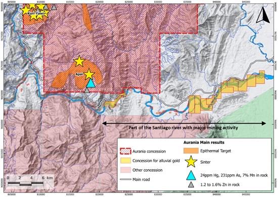
Figure 1. Map showing area of mining activity downstream from Aurania's concessions (not on Aurania's concessions). The concessions for alluvial gold are not property of the Company.
To view an enhanced version of Figure 1, please visit:
We can speculate that 50 excavators might be yielding hundreds of thousands of dollars in gold each day of operation. Our own sampling upstream shows very abundant fine gold in the pan in every sample taken. Presuming that today's miners are extracting only the dregs of the resource, perhaps 450 years ago the Rio Santiago was as rich as Bonanza Creek in the Klondike when first discovered. The richness of the area conforms with Governor Juan de Alderete's account that in the first year of mining almost 30,000 pesos of gold were produced at Logroño. One peso was equal to 4.6g of 'buen oro' (22.5 carat purity - Lane, 1996) making this approximately 4,100 troy ounces. A 1591 document contains one man's report that in one week he and six other miners extracted 350 pesos (more than 1.5 kg) of gold by hand. He said under oath, 'this land was the richest in gold of all the Kingdoms of Peru'.
More work needs to be performed by the Company's technical team to find the potential source(s) of this gold. Further updates will be provided as information becomes available from the field.
Qualified Person
The geological information contained in this news release has been verified and approved by Jean-Paul Pallier, MSc. Mr. Pallier is a designated EurGeol by the European Federation of Geologists and a Qualified Person as defined by National Instrument 43-101, Standards of Disclosure for Mineral Projects of the Canadian Securities Administrators.
About Metron
Metron is a consulting company delivering principled, tailored, scientific solutions that guide decisive actions for solving complex real-world problems and scenarios. Metron is dedicated to developing technical solutions through rigorous innovation grounded in first principles, advanced mathematics, computer science, physics, and engineering.
Metron has 35 years of experience in Bayesian search theory and has developed sophisticated computer algorithms to generate probability maps that identify specific targets even in cases where the data is ambiguous and contradictory. Metron is an established scientific consulting company with a long history of solving very difficult problems. Earlier in his career, Metron Chief Scientist, Dr. Lawrence D. Stone, was part of the team that located the lost nuclear submarine USS SCORPION. He later led the technical team that generated probability maps that led to the discovery of the SS CENTRAL AMERICA: the fabled 'Ship of Gold' that went down in the Atlantic during an 1857 hurricane while carrying 21 tons of California gold. The CENTRAL AMERICA discovery was based largely on the use of historical documentation. More recently, Metron assisted the French government in its search for Air France flight 447 lost over the Atlantic in 2009. Metron's analysis and probability maps guided searchers to the location of the black boxes on the ocean seafloor in 2011.
About Aurania
Aurania is a mineral exploration company engaged in the identification, evaluation, acquisition, and exploration of mineral property interests, with a focus on precious metals and copper in South America. Its flagship asset, The Lost Cities - Cutucu Project, is located in the Jurassic Metallogenic Belt in the eastern foothills of the Andes mountain range of southeastern Ecuador.
Information on Aurania and technical reports are available at and , as well as on Facebook at , Twitter at , and LinkedIn at .
For further information about Aurania, please contact:
Carolyn Muir
VP Investor Relations
Aurania Resources Ltd.
416-367-3200
For information about Metron, please contact:
Robert P. Judd
Vice President, Corporate and Business Development
Metron
Reston, Virginia
707 787 8700
Neither the TSX Venture Exchange nor its Regulation Services Provider (as that term is defined in the policies of the TSX Venture Exchange) accepts responsibility for the adequacy or accuracy of this release.
Forward-Looking Statements
This news release may contain forward-looking information that involves substantial known and unknown risks and uncertainties, most of which are beyond the control of Aurania. Forward-looking statements include estimates and statements that describe Aurania's future plans, objectives or goals, including words to the effect that Aurania or its management expects a stated condition or result to occur. Forward-looking statements may be identified by such terms as 'believes', 'anticipates', 'expects', 'estimates', 'may', 'could', 'would', 'will', or 'plan'. Since forward-looking statements are based on assumptions and address future events and conditions, by their very nature they involve inherent risks and uncertainties. Although these statements are based on information currently available to Aurania, Aurania provides no assurance that actual results will meet management's expectations. Risks, uncertainties and other factors involved with forward-looking information could cause actual events, results, performance, prospects and opportunities to differ materially from those expressed or implied by such forward-looking information. Forward looking information in this news release includes, but is not limited to Aurania's objectives, goals or future plans, statements, exploration results, potential mineralization, the corporation's portfolio, treasury, management team and enhanced capital markets profile, the estimation of mineral resources, exploration, timing of the commencement of operations and estimates of market conditions. Factors that could cause actual results to differ materially from such forward-looking information include, but are not limited to, failure to identify mineral resources, failure to convert estimated mineral resources to reserves, the inability to complete a feasibility study which recommends a production decision, the preliminary nature of metallurgical test results, delays in obtaining or failures to obtain required governmental, regulatory, environmental or other project approvals, political risks, inability to fulfill the duty to accommodate indigenous peoples, uncertainties relating to the availability and costs of financing needed in the future, changes in equity markets, inflation, changes in exchange rates, fluctuations in commodity prices, delays in the development of projects, capital and operating costs varying significantly from estimates and the other risks involved in the mineral exploration and development industry, the effects of COVID-19 on the business of the Company including but not limited to the effects of COVID-19 on the price of commodities, capital market conditions, restrictions on labour and international travel and supply chains, and those risks set out in Aurania's public documents filed on SEDAR. Although Aurania believes that the assumptions and factors used in preparing the forward-looking information in this news release are reasonable, undue reliance should not be placed on such information, which only applies as of the date of this news release, and no assurance can be given that such events will occur in the disclosed time frames or at all. Aurania disclaims any intention or obligation to update or revise any forward-looking information, whether as a result of new information, future events or otherwise, other than as required by law.
To view the source version of this press release, please visit
MENAFN31052022004218003983ID1104298893